Hiking trail around Mont Brion
Add to my favorites

Route closed
A hike between the Abondance and Aulps valleys. All along the way, discoveries await you such as the Serranants mountain pasture, the Col de Savolaire or the Damoz des Moulins lake.
The characteristics of the route.
Abondance (74)
- Distance 9.7 km
- Elevation gain 1030 m
- Elevation lost 1020 m
- Min. elevation 1136 m
- Max. elevation. 1914 m
- Duration (depending on pace) 5h50
- Marking Yes
Departmental signposting PDIPR
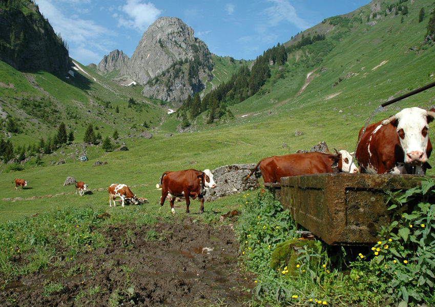
The hike begins with a stop at the Serranants mountain chalets. Here you may meet a herd of Abondance cows, recognisable by their mahogany coat and glasses around their eyes.
You will then reach the combe de Savolaire and then the col de Savolaire (1930 m), where a beautiful view of the mountains of Saint Jean d'Aulps awaits you.
You will then reach the Brion chalets by a steep descent. You are now in the Aulps valley.
When you reach the chalets de Brion, take a path that rises through a forest to the Col de Crèvecoeur and then descends to the lower lake of Damoz des Moulins, then its upper lake, now a high altitude peat bog.
You will then reach the Damoz des Moulin pass which separates the Pic de la Corne and the Mont Brion to discover a panorama of the Abondance valley.
The route back to the chalets of Serranants.Marking : Departmental signposting PDIPREquipments : Car park, Parking, Free car park, Delicate passages : Steep passages that can be slippery, bring good walking shoes and sticks.Admission fee : Free access.Opening : From 01/06 to 31/10. Subject to favorable snow and weather conditions.
Report a problem Add a comment
Website Tour of Mont Brion - Abondance
Add your time and share your feelings


Information updated on 2023-07-26 by Office de Tourisme intercommunal Pays d'Evian Vallée d'Abondance


Follow us on
the digital trails
the digital trails


![]()
Info & contacts
Portes du Soleil Association
1401, route de Vonnes
74390 Châtel FRANCE
+33(0)4.50.73.32.54
info@portesdusoleil.com


OK
Annuler