Tour 12 From Pramenoux to Favardy
Add to my favorites

Route opened
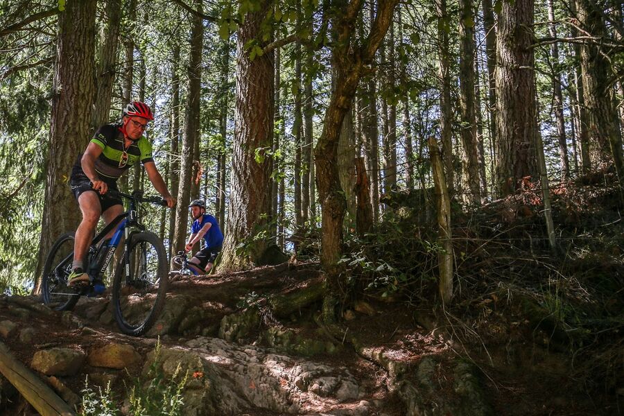
Nice circuit in the woods. Mostly wide track with some physical parts where you may have to push your bike. Some nice false flats and very rolling descents.
The characteristics of the route.
Grandris (69)
- Distance 34 km
- Elevation gain 1290 m
- Elevation lost 1290 m
- Min. elevation 422 m
- Max. elevation. 881 m
- Duration (depending on pace) 2h30 à 3h30
- Marking Yes
Towards the end, a more technical descent with some piloting, some passages in the stones, then a small single which joins Grandris. Possible variation to the BikePark of Lamure-sur-Azergues, at Panissière (km 2). It offers 4 tracks (one green, one blue, one red, one black). Adds 2 km to the circuit.
Between 2h30 to 3h30, depending on the paceMarking : Mark orange with n°12 on a black backgroundAdmission fee : Free access.
Between 2h30 to 3h30, depending on the paceMarking : Mark orange with n°12 on a black backgroundAdmission fee : Free access.
Area : Lac des Sapins
Report a problem
Website Site VTT FFC du Beaujolais Vert Roadbook for sail 
mcalbe
finished in 01:59:00
The 2025/10/16
En savoir plus
Ajouter votre chrono et partager vos sensations
2025/10/16 01:59:00
mcalbe
mcalbe
Pour les amoureux du vtt, pas grand intérêt à ce parcours, et en VTT électrique je ne recommande pas il y a une montée de 20% minimum avec des éboulis de pierre, où il faut pousser le vélo pendant 20' Ce parcours n'a rien de technique, beaucoup de portions bitume,des allés forestières ou montée juste physique Je n'ai pas réussi a aller au bike parc la signalisation L1 pas évidente Sinon tout le balisage en général est top! sauf traversée d'un champs pas très claire
2025/10/16 01:59:00
mcalbe
mcalbe
Pour les amoureux du vtt, pas grand intérêt à ce parcours, et en VTT électrique je ne recommande pas il y a une montée de 20% minimum avec des éboulis de pierre, où il faut pousser le vélo pendant 20' Ce parcours n'a rien de technique, beaucoup de portions bitume,des allés forestières ou montée juste physique Je n'ai pas réussi a aller au bike parc la signalisation L1 pas évidente Sinon tout le balisage en général est top! sauf traversée d'un champs pas très claire
Services nearby
Azergues le plaisir de vivre
Grandris

Maison Louis BUFFIN
Grandris
Au creux du nid
Lamure-sur-Azergues

Maison Familiale Rurale des 4 Vallées
Lamure-sur-Azergues
L'évasion entre prairie et forêts
Lamure-sur-Azergues


Information updated on 2021-08-26 by Office de Tourisme du Beaujolais Vert - Lac des sapins


Follow us on
the digital trails
the digital trails



Info & contacts
Office de Tourisme du Beaujolais Vert
Lac des Sapins - 69550 Cublize
04.74.89.58.03
accueil@beaujolaisvert.com
 Beaujolais Vert Pleine Nature - Parcours - Tour 12 From Pramenoux to Favardy
Hello, world! This is a toast message.
Beaujolais Vert Pleine Nature - Parcours - Tour 12 From Pramenoux to Favardy
Hello, world! This is a toast message.
Beaujolais Vert Pleine Nature - Parcours - Tour 12 From Pramenoux to Favardy
Hello, world! This is a toast message.


OK
Annuler