
Discover outdoor activities

routes filtered
Only my favorites
Delete filters
Around me :
< 5km
< 10km
< 25km
< 50km
Inactive
Difficulties :
Easy
Medium
Difficult
Expert
Durée :
<1h
1-2h
2-3h
3-4h
>4h
Distance (km) :
<10
10-25
25-50
50-75
>75
Distance (km) :
<25
25-50
50-100
100-150
>150
Elevation gain (m) :
<500
500-1000
1000-1500
1500-2500
>2500
Elevation lost (m) :
<500
500-1000
1000-1500
1500-2500
>2500
Tags :
Areas :

Circuit des Landes
17.3km 432m 432m
Bignan
Route opened
17.3km 432m 432m
Bignan
Route opened

Circuit du Tarun
17.22km 290m 290m
Locminé
Route opened
17.22km 290m 290m
Locminé
Route opened

Circuit 19 bleu - Circuit des Lutins
15.63km 480m 480m
Huelgoat
Route opened
15.63km 480m 480m
Huelgoat
Route opened

Route 1 green - Circuit trail des Brigands
10.58km 180m 180m
Bulat-Pestivien
Route opened
10.58km 180m 180m
Bulat-Pestivien
Route opened
Route 2 blue - Circuit trail autour de la Vallée des Papeteries
10.22km 218m 218m
Belle-Isle-en-Terre
Route opened
10.22km 218m 218m
Belle-Isle-en-Terre
Route opened

Route 3 red - Circuit Trail de Coat Noz
27.17km 552m 552m
Belle-Isle-en-Terre
Route opened
27.17km 552m 552m
Belle-Isle-en-Terre
Route opened
Route 4 blue - Circuit Trail du Menez-Bre
19.96km 353m 353m
Louargat
Route opened
19.96km 353m 353m
Louargat
Route opened

Circuit 5 vert - Circuit des Vals du Trieux
7.89km 173m 173m
Saint-Adrien
Route opened
7.89km 173m 173m
Saint-Adrien
Route opened

Circuit 6 bleu - Circuit du Toul Du
13.33km 213m 213m
Plésidy
Route opened
13.33km 213m 213m
Plésidy
Route opened

Circuit 7 bleu - Circuit de l'Abbaye
15.63km 387m 387m
Kerpert
Route opened
15.63km 387m 387m
Kerpert
Route opened

Circuit 7b vert - Circuit des sources
6.88km 171m 171m
Kerpert
Route opened
6.88km 171m 171m
Kerpert
Route opened

Circuit 8 rouge - Circuit du Disquet
27.27km 368m 368m
Kerien
Route opened
27.27km 368m 368m
Kerien
Route opened

Circuit 8b bleu - Circuit de Kiriel
21.16km 209m 209m
Kerien
Route opened
21.16km 209m 209m
Kerien
Route opened

Route 10 green - Tro San Anton
6.87km 137m 137m
Trémargat
Route opened
6.87km 137m 137m
Trémargat
Route opened

Route 11 blue - Tro Kerné Uhel
13.63km 213m 213m
Trémargat
Route opened
13.63km 213m 213m
Trémargat
Route opened

Route 12 blue - Circuit de la grande tranchée des bagnards - Etang du
18.02km 176m 176m
Glomel
Route opened
18.02km 176m 176m
Glomel
Route opened

Route 13 vert - Étang du Korong
6.08km 19m 19m
Glomel
Route opened
6.08km 19m 19m
Glomel
Route opened
Route 20 green - Circuit découverte de Huelgoat
8.7km 210m 210m
Huelgoat
Route opened
8.7km 210m 210m
Huelgoat
Route opened

Route 21 blue - Circuit des chevreuils
19.9km 470m 470m
Huelgoat
Route opened
19.9km 470m 470m
Huelgoat
Route opened

Route 22 blue - Tour du Yeun Elez
17.91km 124m 124m
Brasparts
Warning
17.91km 124m 124m
Brasparts
Warning

Route 30 green - Sentier poétique
6.08km 62m 62m
Châteauneuf-du-Faou
Route opened
6.08km 62m 62m
Châteauneuf-du-Faou
Route opened

Route 40 green - Les Chaos de L'Ellé
7.6km 222m 222m
Le Faouët
Route opened
7.6km 222m 222m
Le Faouët
Route opened

Route 42 blue - Circuit des Chapelles
20.74km 342m 342m
Le Faouët
Route opened
20.74km 342m 342m
Le Faouët
Route opened

Route 43 blue - Circuit des carrières
11.22km 175m 175m
Gourin
Route opened
11.22km 175m 175m
Gourin
Route opened

Route 44 blue - Tour des Montagnes Noires
16.68km 282m 282m
Gourin
Route opened
16.68km 282m 282m
Gourin
Route opened

Route 45 red - Grand tour des Montagnes Noires
28.24km 463m 463m
Gourin
Route closed
28.24km 463m 463m
Gourin
Route closed

Route 50 blue - Circuit de Castennec
12.21km 251m 251m
Bieuzy
Route opened
12.21km 251m 251m
Bieuzy
Route opened

Route 51 blue - Circuit de Rimaison
22.41km 410m 410m
Pluméliau-Bieuzy
Route opened
22.41km 410m 410m
Pluméliau-Bieuzy
Route opened

Route 60 green - La Chapelle Sainte Tréphine
13.36km 169m 169m
Pontivy
Route opened
13.36km 169m 169m
Pontivy
Route opened

Route 61 red - Tour de Pontivy - Tro Pondi
28.78km 366m 366m
Pontivy
Route opened
28.78km 366m 366m
Pontivy
Route opened
Route 62 blue - Boucle de Stival
19.07km 271m 271m
Pontivy
Route opened
19.07km 271m 271m
Pontivy
Route opened
Route 63 - Trail urbain de Pontivy
9.62km 111m 111m
Pontivy
Route opened
9.62km 111m 111m
Pontivy
Route opened

Route 70 green - Anse de Landroannec
10.23km 146m 146m
Guerlédan
Route opened
10.23km 146m 146m
Guerlédan
Route opened
Route 71 blue - Le Bois de Caurel
14.13km 238m 238m
Guerlédan
Route opened
14.13km 238m 238m
Guerlédan
Route opened

Route 72 red - Tour du Lac de Guerlédan
36.5km 790m 790m
Guerlédan
Route opened
36.5km 790m 790m
Guerlédan
Route opened
Circuit 80 vert - Circuit des moulins - Hent ar meilhoù
6.8km 180m 180m
Carhaix
Route opened
6.8km 180m 180m
Carhaix
Route opened

Circuit 80 Famille - Circuit des moulins - Hent ar meilhoù
2.64km 61m 61m
Carhaix
Route opened
2.64km 61m 61m
Carhaix
Route opened
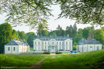
Route 90 blue - Boucle du Château de Kerguéhennec
13.9km 240m 240m
Bignan
Route opened
13.9km 240m 240m
Bignan
Route opened


International
France
 Destination Cœur de Bretagne - Liste des activités

