Cenise Pass - Hike
Add to my favorites

Route closed
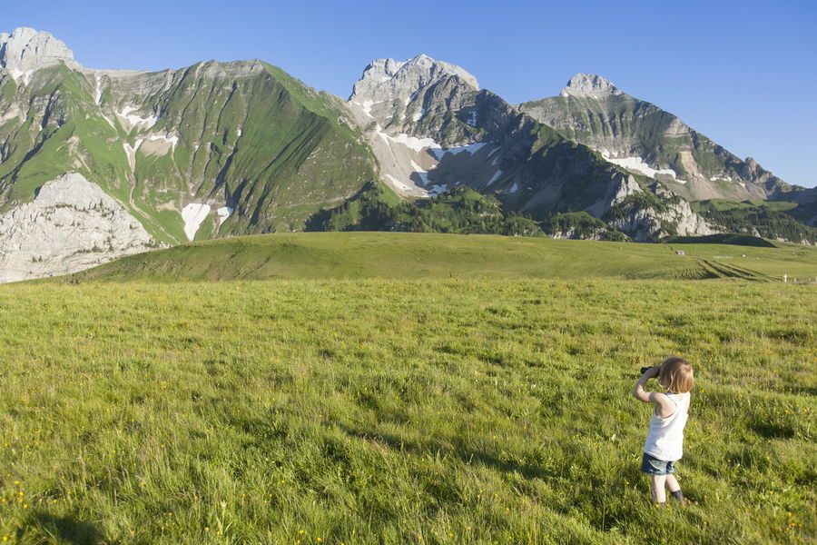
A quiet stroll in a majestic setting that makes our heads spin 360°. Landscapes of character open on the chain of Bargy and on the valley of Arve.
The characteristics of the route.

Mont-Saxonnex (74)
- Distance 3.58 km
- Elevation gain 160 m
- Elevation lost 160 m
- Min. elevation 1571 m
- Max. elevation. 1724 m
- Duration (depending on pace) 1h05
- Marking Yes
Starting point : car park on Les Frachets Plateau in Mont-Saxonnex, near the farm From Les Frachets (car-park) to La Croix du Felay : 25 mins On foot, follow the road starting in front of Les Frachets farm. The slope is gentle and the path wide. You will cross the alpine pastures until la Croix du Felay (a cross). From La Croix du Felay to Cenise Pass : 10mins From the cross, follow the path. The wide plateau opens in front of you and you will be able to see the Rochers de Leschaux on your right and le Bargy mountain range on your left. From the Pass to the car-park : Go back with the same route. To do more from Cenise Pass : * Les Rochets de Leschaux : 1h05mins (one-way) for good hikers * Le Jalouvre (for very good hikers, very delicate passage on the Razor's Pass, route not signed) : 2h50mins (one way) * Lessy's Lake (not signed) : 1h40minsThe Cenise plateau extends from the Bargy massif to the Rochers de Leschaux, straddling three municipalities and two intermunicipalities: the municipality of Mont-Saxonnex, located on the territory of the Community of Municipalities Cluses Arve and Mountains (2CCAM), and the communes of Glières-Val-de-Borne and Brison, located on the territory of the Community of Communes Faucigny-Glières (CCFG). The site offers a very open landscape with the subalpine lawns which occupy it, thus allowing an unobstructed view of the main peaks of Bargy. The plateau presents 630 hectares of rich and varied natural environments, supports of exceptional fauna and flora: karstic environments, ponds and wetlands, high altitude lawns.
Due to its remarkable natural heritage and its unique landscape setting, the Cenise plateau is included in the Natura 2000 site of the Bargy massif, designated to protect a certain number of habitats and species representative of European biodiversity. It is also in the process of being labeled Espace Naturel Sensible (ENS), a label awarded by the Department for sites intended to be preserved and promoted to the general public. This ENS policy is carried out at the local level by the Community of Communes Cluses Arve et Montagnes (2CCAM), which is responsible for the implementation of a management plan finalized in 2022: this document consists of drawing up an inventory of the site and actions to be implemented to reconcile attendance and preservation.
All the fauna typical of the mountain environment can be observed there: ibexes, chamois, marmots, black grouse… The site is also flown over by the bearded vulture, a large vulture reintroduced into the Bargy massif at the end of the 1980s. Wetlands and the meadows are particularly interesting from the floristic and faunal point of view.
The Cenise plateau is marked by high visitor numbers and presents conflicts of use, particularly in connection with the work carried out by the alpine pasture farmers on the land grazed by the cattle herds which maintain the site. Attendance, if it is not channeled and respectful, induces significant disturbances both for the mountain pasture but also for the biodiversity of the site. The communities and the various local players are working to solve the problems encountered, in particular by implementing the actions defined in the site management plan.Marking : Trail marked with directional posts (PDIPR)Admission fee : Free access. Guidebook on sale at the Tourist Office.Opening : Closed temporarily.
Area : Cluses Arve & Montagnes
Report a problem
Website Cenise plateau leaflet PDF map
Add your time and share your feelings


Information updated on 2026-04-29 by Cluses Arve & montagnes Tourisme


Follow us on
the digital trails
the digital trails


![]()
Infos & contacts
Flaine Tourist Office
Tél. +33 (0)4 50 90 80 01
Les Carroz sports club
sports@aracheslafrasse.fr - Tél. +33 (0)4 50 90 24 80
Cluses Arve & montagnes Tourist Office
Tél. +33 (0)4 50 96 69 69
 Espace Trail Flaine - Les Carroz - Cluses Arve et Montagnes - Parcours - Cenise Pass - Hike
Hello, world! This is a toast message.
Espace Trail Flaine - Les Carroz - Cluses Arve et Montagnes - Parcours - Cenise Pass - Hike
Hello, world! This is a toast message.
Espace Trail Flaine - Les Carroz - Cluses Arve et Montagnes - Parcours - Cenise Pass - Hike
Hello, world! This is a toast message.


OK
Annuler