La Pellaz - Hike
Add to my favorites

Route opened
An accessible route for all. In summer as in winter, it is nice to follow the torrent, called the Bronze. A feeling of calm and well-being in a natural setting.
The characteristics of the route.

Mont-Saxonnex (74)
- Distance 7.16 km
- Elevation gain 330 m
- Elevation lost 330 m
- Min. elevation 954 m
- Max. elevation. 1278 m
- Duration (depending on pace) 2h35
- Marking Yes
Topo step by step :
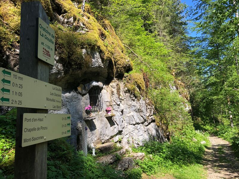
From Chapelle de Pincru to La Gouille: 40 minutes From the car park, follow the signs for ‘Les Glaciers’ and then ‘La Chèvrerie - Les Oulettes’. The road takes you to the farm (where you can buy cheese). Take the path on the left in front of the cheese dairy as far as the bridge. Once at the bridge, take the path on the right and join the track that climbs steadily through the forest to the oratory at La Gouille. This leads to a small road at the ‘La Gouille’ sign. Variation: make a return trip to Les Glaciers (1 hour each way) From La Gouille to La Pellaz: 45 minutes Turn around and retrace your steps to the La Gouille junction. Then turn left towards Morsullaz (without going there), and at the slopes, follow the path to La Pella. From La Pellaz to La Chapelle de Pincru: 1 hour 10 mins Return along the same route to the Chapelle car park.Marking : Trail marked with directional posts (PDIPR)Equipments : Public WC, Admission fee : Free access. Guidebook on sale at the Tourist Office.Opening : From 01/04 to 14/11. Subject to favorable snow and weather conditions.
From Chapelle de Pincru to La Gouille: 40 minutes From the car park, follow the signs for ‘Les Glaciers’ and then ‘La Chèvrerie - Les Oulettes’. The road takes you to the farm (where you can buy cheese). Take the path on the left in front of the cheese dairy as far as the bridge. Once at the bridge, take the path on the right and join the track that climbs steadily through the forest to the oratory at La Gouille. This leads to a small road at the ‘La Gouille’ sign. Variation: make a return trip to Les Glaciers (1 hour each way) From La Gouille to La Pellaz: 45 minutes Turn around and retrace your steps to the La Gouille junction. Then turn left towards Morsullaz (without going there), and at the slopes, follow the path to La Pella. From La Pellaz to La Chapelle de Pincru: 1 hour 10 mins Return along the same route to the Chapelle car park.Marking : Trail marked with directional posts (PDIPR)Equipments : Public WC, Admission fee : Free access. Guidebook on sale at the Tourist Office.Opening : From 01/04 to 14/11. Subject to favorable snow and weather conditions.
Area : Cluses Arve & Montagnes
Report a problem
Website PDF map THIS ROUTE IN YOUR MOBILE PHONE
Download Flaine Carroz 2ccam Outdoor app
Get all the routes on your smartphone with Flaine Carroz 2ccam Outdoor app. You'll find a host of functions :
- Take advantage of detailed IGN maps
- Download data for consultation even when you're not connected to the network
- Geolocate yourself at any time on the route and altimeter profile
- Activate the off-track alarm to be alerted if you stray from the itinerary
- Find nearby services
- Share your experience (add a report, share your lap time)...

Add your time and share your feelings


Information updated on 2025-02-13 by Cluses Arve & montagnes Tourisme


Follow us on
the digital trails
the digital trails


![]()
Infos & contacts
Flaine Tourist Office
Tél. +33 (0)4 50 90 80 01
Les Carroz sports club
sports@aracheslafrasse.fr - Tél. +33 (0)4 50 90 24 80
Cluses Arve & montagnes Tourist Office
Tél. +33 (0)4 50 96 69 69
 Espace Trail Flaine - Les Carroz - Cluses Arve et Montagnes - Parcours - La Pellaz - Hike
Hello, world! This is a toast message.
Espace Trail Flaine - Les Carroz - Cluses Arve et Montagnes - Parcours - La Pellaz - Hike
Hello, world! This is a toast message.
Espace Trail Flaine - Les Carroz - Cluses Arve et Montagnes - Parcours - La Pellaz - Hike
Hello, world! This is a toast message.


OK
Annuler