Alpage de la Biolle and Praz Bassoux - Hike
Add to my favorites

Route opened
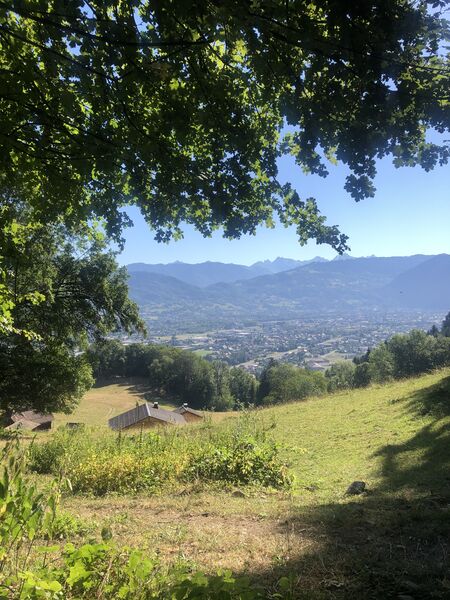
A route that winds through alpine meadows and forests without much difficulty. This hike will teach you about the area thanks to the stops along the “Vardafe” marnerote themed trail. Along the way, you’ll discover scenic views of the Cluses Valley.
The characteristics of the route.

Marnaz (74)
- Distance 3.87 km
- Elevation gain 260 m
- Elevation lost 260 m
- Min. elevation 537 m
- Max. elevation. 767 m
- Duration (depending on pace) 2h05
- Marking Yes
From Marnaz to the Oratory of La Biolle: 45 minutes Take the path through the forest; it climbs steadily up to the renovated and refurbished log cabin, where you can learn about the history of La Biolle. From the Oratory of La Biolle to La Chardaz: 15 minutes At the Oratory (built in 1887), continue straight ahead toward Praz Bassoux. After 500 meters, take the footbridge. At the intersection, head down to the right, cross the stream, and walk 500 meters uphill to the La Chardaz sign. From La Chardaz to Praz Bassoux: 25 minutes At La Chardaz, head toward Praz Bassoux to the right. Follow the flat path through the forest, then cross a field before reaching the road. Walk down the road for about 100 meters, then at the “Chedde” sign, take a path on your right. Walk down through the field and continue into the forest. When you emerge from the woods, head straight down through the field to the Praz Bassoux cabins. From Praz Bassoux to the Ruisseau du Chêne: 15 minutes From the cabins, head down toward the lone tree in the field on the right. From the Praz Bassoux sign, cross the field straight ahead to the edge of the woods. Then, go through the gate to leave the field and enter the forest. Cross the stream via the footbridge and continue your descent. From Ruisseau du Chêne to Marnaz-Centre: 25 minutes At the Ruisseau du Chêne sign, head toward Marnaz. The forest path levels out and leads you back to the Chez Vavin parking lot; then follow the road to return to the starting point. To extend the hike from La Chardaz: Lac Bénit. Duration: 2 hours 45 minutes (one way)Please respect the flora and fauna, which have already been weakened by winter. Keep your dogs on a leash. Pick up after your pets.Marking : Trail marked with directional posts (PDIPR)Equipments : Car park, Admission fee : Free access. Hiking maps are available for purchase at the tourist office.Opening : From 01/04 to 14/11 daily.
Area : Cluses Arve & Montagnes
Report a problem
Website PDF map THIS ROUTE IN YOUR MOBILE PHONE
Download Flaine Carroz 2ccam Outdoor app
Get all the routes on your smartphone with Flaine Carroz 2ccam Outdoor app. You'll find a host of functions :
- Take advantage of detailed IGN maps
- Download data for consultation even when you're not connected to the network
- Geolocate yourself at any time on the route and altimeter profile
- Activate the off-track alarm to be alerted if you stray from the itinerary
- Find nearby services
- Share your experience (add a report, share your lap time)...


Renard1-
The 2026/09/06
En savoir plus
mjjm
The 2023/07/28
En savoir plus
Ajouter votre chrono et partager vos sensations
2026/09/06 Renard1-
2023/07/28 mjjm
Belle promenade didactique.
2026/09/06 Renard1-
2023/07/28 mjjm
Belle promenade didactique.


Information updated on 2026-07-14 by Cluses Arve & montagnes Tourisme


Follow us on
the digital trails
the digital trails




Infos & contacts
Flaine Tourist Office
Tél. +33 (0)4 50 90 80 01
Les Carroz sports club
sports@aracheslafrasse.fr - Tél. +33 (0)4 50 90 24 80
Cluses Arve & montagnes Tourist Office
Tél. +33 (0)4 50 96 69 69
 Espace Trail Flaine - Les Carroz - Cluses Arve et Montagnes - Parcours - Alpage de la Biolle and Praz Bassoux - Hike
Hello, world! This is a toast message.
Espace Trail Flaine - Les Carroz - Cluses Arve et Montagnes - Parcours - Alpage de la Biolle and Praz Bassoux - Hike
Hello, world! This is a toast message.
Espace Trail Flaine - Les Carroz - Cluses Arve et Montagnes - Parcours - Alpage de la Biolle and Praz Bassoux - Hike
Hello, world! This is a toast message.



OK
Annuler