Chemin des Colporteurs - Hike
Add to my favorites

Route opened
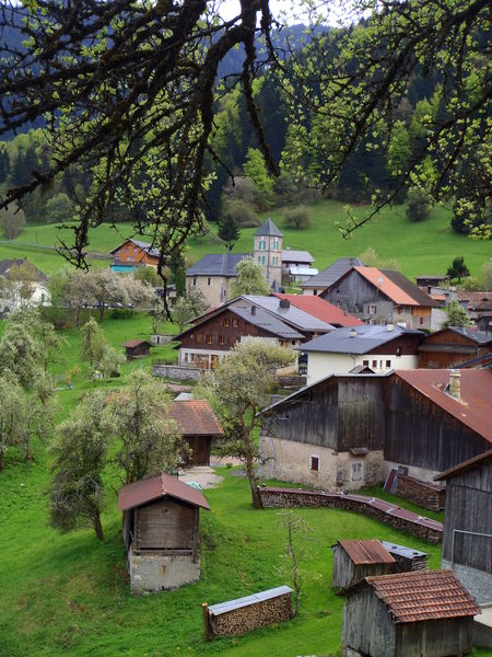
Discover the area’s heritage, wildlife, and plants through 10 informative and fun interpretive signs placed along the trail. Follow Eliot, the tawny owl, as he reveals the secrets of the forest and the lives of the peddlers.
The characteristics of the route.

Nancy-sur-Cluses (74)
- Distance 3.71 km
- Elevation gain 140 m
- Elevation lost 140 m
- Min. elevation 921 m
- Max. elevation. 1043 m
- Duration (depending on pace) 1h
- Marking Yes
Step-by-Step Directions: Town Hall – La Fley Chapel: 10 minutes From the town hall in Nancy-sur-Cluses, take the road coming from Cluses. Before leaving the village, take the small road branching off to the left, following the sign for “La Chapelle Tour des Crêtes .” The paved road then becomes a trail overlooking the village; continue along it to the Chapel of La Fley, following the “Chouette Eliot” trail markers. From the Fley Chapel to La Frasse: 45 minutes Once you reach the chapel, take the steep path for 200 meters. It climbs to the left immediately after the chapel (do not continue straight ahead). After the climb, at the trail junction, turn right. Continue to the power line tower and enjoy the unobstructed view of Cluses to your right. When you reach an intersection, turn left, following the signs for Nancy via Les Crêtes (yellow markings). Walk along the edge of the woods and continue uphill for 100 meters. At the intersection, follow the road to the left toward Nancy (yellow markings). Descend until you reach the departmental road; cross it and follow the signs for “Le Moulin.” Continue down the paved road until you reach the houses. From there, at the intersection, turn left to reach the village of La Frasse. You’ll pass, in succession, the remarkable restored granary, the old peddlers’ houses with the number 4 decorating the tops of their doors, the twin ovens, and the La Frasse Chapel. From La Frasse to City Hall: 5 minutes After the chapel, continue to the right to reach the parking lot and the church in Nancy-sur-Cluses.This route is partially accessible with a stroller.Marking : Wooden signs at the start.
Trail marked by directional posts (PDIPR)Equipments : Car park, Good plans : This route is partially accessible with a stroller.Admission fee : Free access. Hiking maps are available for purchase at the tourist office.Opening : From 01/04 to 14/11 daily.
Area : Cluses Arve & Montagnes
Report a problem
Website PDF map THIS ROUTE IN YOUR MOBILE PHONE
Download Flaine Carroz 2ccam Outdoor app
Get all the routes on your smartphone with Flaine Carroz 2ccam Outdoor app. You'll find a host of functions :
- Take advantage of detailed IGN maps
- Download data for consultation even when you're not connected to the network
- Geolocate yourself at any time on the route and altimeter profile
- Activate the off-track alarm to be alerted if you stray from the itinerary
- Find nearby services
- Share your experience (add a report, share your lap time)...


mjjm
The 2021/08/13
En savoir plus
Ajouter votre chrono et partager vos sensations
2021/08/13 mjjm
Très belle promenade avec un beau parcours didactique pour les enfants. Attention de bien prendre à droite après la chapelle.
2021/08/13 mjjm
Très belle promenade avec un beau parcours didactique pour les enfants. Attention de bien prendre à droite après la chapelle.


Information updated on 2026-04-27 by Cluses Arve & montagnes Tourisme


Follow us on
the digital trails
the digital trails




Infos & contacts
Flaine Tourist Office
Tél. +33 (0)4 50 90 80 01
Les Carroz sports club
sports@aracheslafrasse.fr - Tél. +33 (0)4 50 90 24 80
Cluses Arve & montagnes Tourist Office
Tél. +33 (0)4 50 96 69 69
 Espace Trail Flaine - Les Carroz - Cluses Arve et Montagnes - Parcours - Chemin des Colporteurs - Hike
Hello, world! This is a toast message.
Espace Trail Flaine - Les Carroz - Cluses Arve et Montagnes - Parcours - Chemin des Colporteurs - Hike
Hello, world! This is a toast message.
Espace Trail Flaine - Les Carroz - Cluses Arve et Montagnes - Parcours - Chemin des Colporteurs - Hike
Hello, world! This is a toast message.


OK
Annuler