Theys - Entre Hameaux - Prairies et Forêts
Add to my favorites

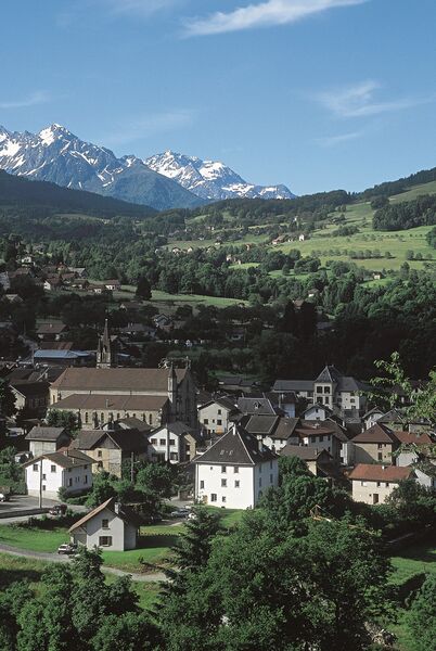
Exposée au sud, sur les hauts de Theys, cette randonnée permet d'évoluer dans des sites variés et préservés.
The characteristics of the route.

Theys (38)
- Distance 7.4 km
- Elevation gain 270 m
- Elevation lost 270 m
- Min. elevation 611 m
- Max. elevation. 828 m
- Marking Yes
Equipments : Car park, Free car park, Admission fee : Free of charge.Opening : All year round.
Subject to favorable weather.
Area : Grésivaudan
Report a problem Add a comment
Pdf file Features of the application :
- Location and orientation on detailed maps thanks to the GPS of your smartphone
- Description of routes and points of interest on the route
- Photo gallery by route
- Detailed elevation profile
- Route tracking alert to warn you if you stray from the route
- Send predefined messages by SMS to your contacts
- Emergency module: trigger a call or send an emergency SMS in case of problem
- Agenda: access to events organized in the department
- News: find in the application the latest news on the web portal
- Adding achievements
- Add reports in case of problems encountered on the routes
- Share on social networks
AnnabelleB
finished in 01:34:00
The 2023/05/28
En savoir plus
Ajouter votre chrono et partager vos sensations
2023/05/28 01:34:00
AnnabelleB
AnnabelleB
2023/05/28 01:34:00
AnnabelleB
AnnabelleB
Services nearby

Foyer de ski de fond du Barioz
Crêts en Belledonne

Bureau d'Information Touristique de Prapoutel / Les 7 Laux - Office de Tourisme Belledonne Chartreuse
Les Sept Laux Prapoutel
Bureau d'Information Touristique du Pleynet / Les 7 Laux - Office de Tourisme Belledonne Chartreuse
Les Sept Laux Le Pleynet

Crêt du Poulet refuge
Crêts en Belledonne

Espace naturel sensible du Marais de Montfort
Crolles


Information updated on 2021-06-08 by Office de Tourisme de Belledonne Chartreuse


Follow us on
the digital trails
the digital trails


![]()
The Isère Outdoor application was created
by the Département de l'Isère
Infos & contact
Conseil départemental de l'Isère
7 rue Fantin Latour
CS 41096
38 022 Grenoble cedex 1
Tel. 04 76 00 38 38


OK
Annuler