Le Canal de Pellafol - 12 km - Bleu
Add to my favorites

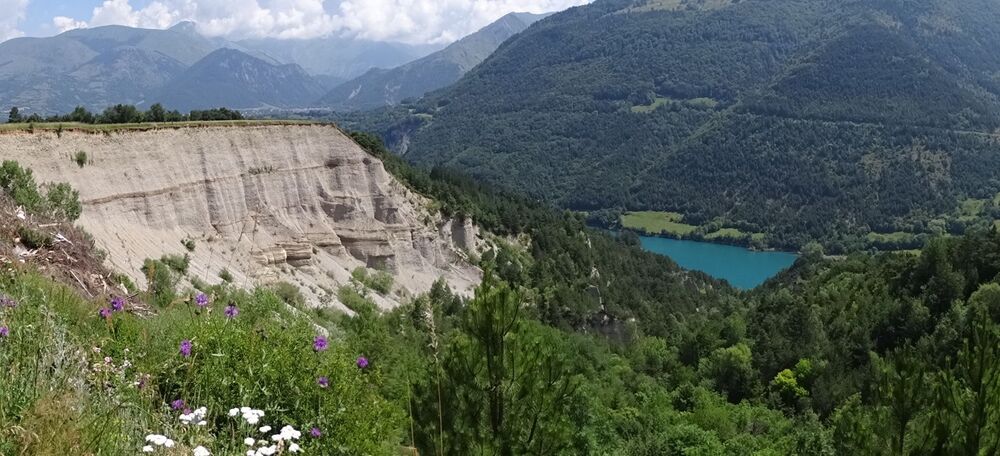
Profitez des vues atypiques sur les formations géologiques surprenantes de ce coin de Matheysine. Une boucle qui vous fera connaître des hauts et des bas…
The characteristics of the route.
Pellafol (38)
- Distance 11.81 km
- Elevation gain 469 m
- Elevation lost 469 m
- Min. elevation 764 m
- Max. elevation. 1027 m
- Marking Yes
Admission fee : Free access.Opening : All year round.
Area : Matheysine
Report a problem
Website Pdf file Features of the application :
- Location and orientation on detailed maps thanks to the GPS of your smartphone
- Description of routes and points of interest on the route
- Photo gallery by route
- Detailed elevation profile
- Route tracking alert to warn you if you stray from the route
- Send predefined messages by SMS to your contacts
- Emergency module: trigger a call or send an emergency SMS in case of problem
- Agenda: access to events organized in the department
- News: find in the application the latest news on the web portal
- Adding achievements
- Add reports in case of problems encountered on the routes
- Share on social networks
Add your time and share your feelings
Services nearby

Heritage House
Pellafol

Maison du tourisme de Corps
Corps

Espace Naturel Sensible Sources des Gillardes
Pellafol

Foyer nordique de Tréminis
Tréminis
Bureau d'Informations Touristiques de Mens - Office de Tourisme du Trièves
Mens


Information updated on 2021-08-04 by Matheysine Tourisme


Follow us on
the digital trails
the digital trails


![]()
The Isère Outdoor application was created
by the Département de l'Isère
Infos & contact
Conseil départemental de l'Isère
7 rue Fantin Latour
CS 41096
38 022 Grenoble cedex 1
Tel. 04 76 00 38 38
 Isère Outdoor - Parcours - Le Canal de Pellafol - 12 km - Bleu
Hello, world! This is a toast message.
Isère Outdoor - Parcours - Le Canal de Pellafol - 12 km - Bleu
Hello, world! This is a toast message.
Isère Outdoor - Parcours - Le Canal de Pellafol - 12 km - Bleu
Hello, world! This is a toast message.


OK
Annuler