Route 25 - Le Theil
Add to my favorites

Route opened
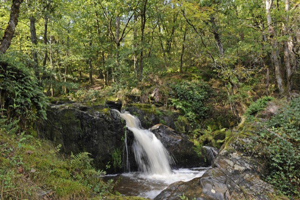
Un passage au cascades des Moulines et des points de vue sur la vallée de la Creuse.
The characteristics of the route.
Anzême (23)
- Distance 11.3 km
- Elevation gain 270 m
- Elevation lost 270 m
- Min. elevation 274 m
- Max. elevation. 388 m
- Duration (depending on pace) 2h30
- Marking yellow
Isa-A33
The 2024/08/23
En savoir plus
Ajouter votre chrono et partager vos sensations
2024/08/23 Isa-A33
Jolie rando, le détour par les cascades de la mouline est sympa (surtout pour mon chien qui a apprécié la fraîcheur de l'eau). Attention tout de même à la remontée sur anzeme, ça pique un peu les mollets ????
2024/08/23 Isa-A33
Jolie rando, le détour par les cascades de la mouline est sympa (surtout pour mon chien qui a apprécié la fraîcheur de l'eau). Attention tout de même à la remontée sur anzeme, ça pique un peu les mollets ????
Services nearby

Camping La Chevauchée
BUSSIERE-DUNOISE

Chambres d'hôtes - 2/4 pers- Mme BERTRI
BUSSIERE-DUNOISE
Camping de la Vergne
BUSSIERE-DUNOISE
Chambre d'hôtes 4 personnes - M.BODEAU
GUERET
LES HIRONDELLES
GLENIC


Follow us on
the digital trails
the digital trails


![]()
Info & contacts :
Communauté d'Agglomération du Grand Guéret
Service Sports de nature
Tel : +33(0)5 55 41 04 48
contact@sportsnature-montsdegueret.com
 Station Sports Nature des Monts de Guéret - Parcours - Route 25 - Le Theil
Hello, world! This is a toast message.
Station Sports Nature des Monts de Guéret - Parcours - Route 25 - Le Theil
Hello, world! This is a toast message.
Station Sports Nature des Monts de Guéret - Parcours - Route 25 - Le Theil
Hello, world! This is a toast message.


OK
Annuler