La combe des Aiguilles d'Arves - Hiking itinerary
Add to my favorites

Route closed
Keep your eyes peeled for marmots.
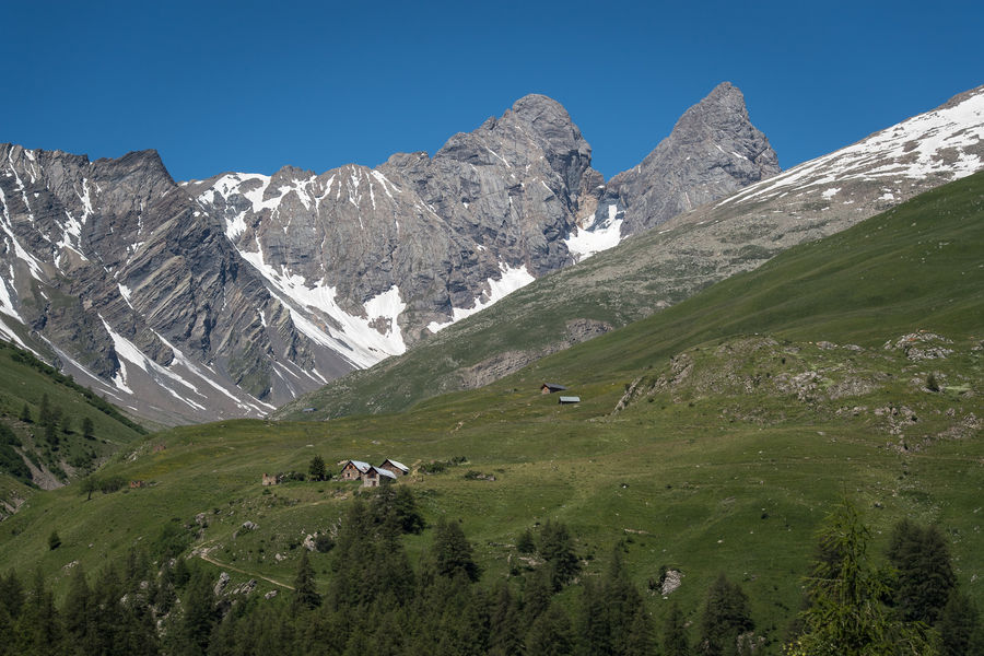
Discover the great circus formed by these three Savoyard needles.
The characteristics of the route.
Hameaux de Bonnenuit (73)
- Distance 11.76 km
- Elevation gain 750 m
- Elevation lost 750 m
- Min. elevation 1680 m
- Max. elevation. 2382 m
- Duration (depending on pace) 5h30
- Marking Yes
To activate geolocation, click on the map icon.Marking : The trail is marked with yellow directional signs.Good plans : ?? Some snow may remain. Please be careful.
There are a few things you can do to make your hiking experience safer and more enjoyable. Walking poles (even on roads) improve balance in icy conditions, crampons provide grip, and regular hydration is essential.
Carry a water bottle and snacks to keep your energy up. Protect yourself from the sun with sunscreen and sunglasses. Don't forget binoculars to add a touch of observation to your adventure.
Finally, check weather conditions and avalanche risks before you set off. Inform someone of your itinerary, as communication may be limited. These small adjustments will help you make the most of your getaway.Admission fee : Free access.Opening : From 15/05 to 15/10.
Subject to favorable snow and weather conditions.Step by step description : Start: Car park below the Bonnenuit altiport.
1/ Take the forest path leading to the Chalets des Aiguilles.
2/ Continue to the Aiguilles d'Arves refuge.
3/ After the refuge, climb up the combe des Aiguilles to the foot of the large névé (until end of July) arriving near the torrent.
4/ Descend by the same route (or, at the Commandraut junction, return to La Rivine or Les Verneys via Le Vallon).
Report a problem
Website Pdf file 55555
The 2025/07/31
En savoir plus
gau_carlier
finished in 04:45:00
The 2025/07/09
En savoir plus
Ajouter votre chrono et partager vos sensations
2025/07/31 55555
2025/07/09 04:45:00
gau_carlier
gau_carlier
début de montée un peu dur sans préparation. puis pente régulière sans difficultés jusqu'au refuge et à la combe
2025/07/31 55555
2025/07/09 04:45:00
gau_carlier
gau_carlier
début de montée un peu dur sans préparation. puis pente régulière sans difficultés jusqu'au refuge et à la combe
Services nearby

Médiation par l'animal avec Husky en thérapie
601 chemin de Bonnenuit

Brico Net 73
Chemin de Bonnenuit
Briconet 73
Chemin de Bonnenuit
Brico Net 73
Chemin de Bonnenuit

Dog boarding You Ski en Terre Happy
601 chemin de Bonnenuit


Information updated on 2025-05-13 by Office de Tourisme de Valloire


Follow us on
the digital trails
the digital trails


![]()
Valloire Tourist Office
210 rue des Grandes Alpes - 73450 Valloire
+33(0)4 79 59 03 96
Office de Tourisme
Contact mail
 Valloire Galibier Expériences - Parcours - La combe des Aiguilles d'Arves - Hiking itinerary
Hello, world! This is a toast message.
Valloire Galibier Expériences - Parcours - La combe des Aiguilles d'Arves - Hiking itinerary
Hello, world! This is a toast message.
Valloire Galibier Expériences - Parcours - La combe des Aiguilles d'Arves - Hiking itinerary
Hello, world! This is a toast message.


OK
Annuler