Col de la Plagnette - Hiking trail
Add to my favorites

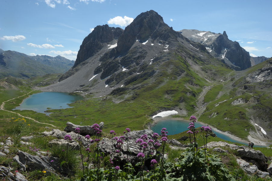
The interest of this hike is the observation of wild fauna such as marmots and chamois. You can also see herds of cattle throughout the walk.
The characteristics of the route.
Pontet (73)
- Distance 21.4 km
- Elevation gain 1150 m
- Elevation lost 1150 m
- Min. elevation 1452 m
- Max. elevation. 2520 m
- Duration (depending on pace) 7h30
- Marking Yes
To activate geolocation, click on the map icon.Marking : The trail is marked with yellow directional signs.Good plans : When hiking, there are a few things you can do to make your experience safer and more enjoyable. Walking poles (even on roads) improve balance in icy conditions, crampons provide grip, and regular hydration is essential.
Carry a water bottle and snacks to keep your energy up. Protect yourself from the sun with sunscreen and sunglasses. Don't forget binoculars to add a touch of observation to your adventure.
Finally, check weather conditions and avalanche risks before you set off. Inform someone of your itinerary, as communication may be limited. These small adjustments will help you make the most of your getaway.Admission fee : Free access.Opening : All year round.
Subject to favorable snow and weather conditions.Step by step description : Departure point: hamlet of Le Pontet. 1 - Reach the hamlet of Archaz (or drive to Archaz). 2 - The route climbs up the Neuvachette valley, passing through Les Selles and old alpine chalets. 3 - Reach the Col de la Plagnette. On the plateau, discover an ancient 18th-century fort. 4 - Return along the same path or via Col des Rochilles and Les Mottets.
Report a problem Add a comment
Website Pdf file
Add your time and share your feelings
Services nearby

La Ruade Sport
Place de Tigny

Skibicki Jacky
La Fornache

Les Essarts
Hameau de Tigny

Maison de la Presse - Grange Sport
rue de la Sétaz
Grange Sport - Jean-Baptise GRANGE - Netski
rue de la Sétaz


Information updated on 2024-06-07 by Office de Tourisme de Valloire


Follow us on
the digital trails
the digital trails


![]()
Valloire Tourist Office
210 rue des Grandes Alpes - 73450 Valloire
+33(0)4 79 59 03 96
Office de Tourisme
Contact mail


OK
Annuler