9 - Le tour des lacs return via the Combe de l'Aiguille Noire - MTB / VTTAE itinerary
Add to my favorites

Route closed
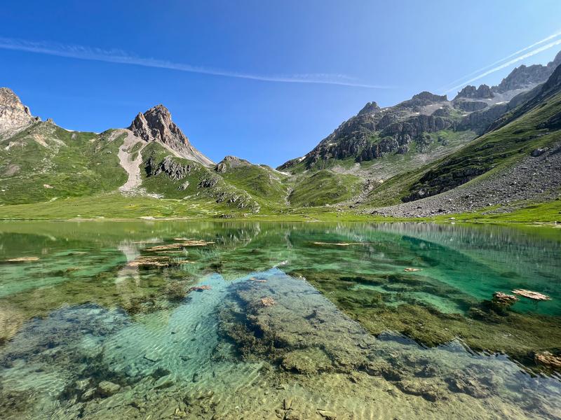
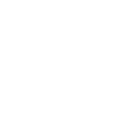
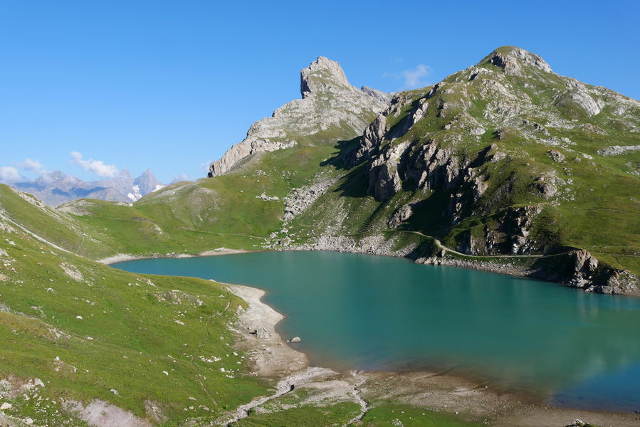
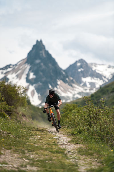
This circuit is a technical variant of the 3 lakes ride, a must in Valloire. Ride to the foot of the Aiguille Noire and admire the alpine chalets that you will come across on your return. We strongly advise you to take your picnic in order to leave for the day and enjoy the mountain lakes whose turquoise waters will take your breath away.
The characteristics of the route.
Office de tourisme de Valloire (73)
- Distance 28.02 km
- Elevation gain 1190 m
- Elevation lost 1190 m
- Min. elevation 1402 m
- Max. elevation. 2518 m
- Duration (depending on pace) 5h
- Marking Yes
We strongly advise you to bring your own picnic for a day out, and enjoy the turquoise waters of the mountain lakes.
To activate geolocation, click on the map icon.Marking : The trail is marked with signs.Equipments : Free car park, Car park, Picnic area, Good plans : Precautions: - The routes you take are your own responsibility. You must choose a route adapted to your physical and technical capacity. If in doubt, do not hesitate to contact mountain professionals. - Find out about the weather conditions before your departure. - Be properly equipped to practice hiking in complete safety and deal with the vagaries of the weather. Tell someone if you are leaving alone and prefer a morning departure so as not to be surprised by the night.Admission fee : Free access.Opening : From 21/05 to 23/10 daily. Subject to favorable weather.Step by step description : Departure - From the tourist office, head up Rue des Grandes Alpes towards the hamlet of Les Verneys 1 - Once you've crossed the bridge, walk along the parking lot to take the footbridge on the left of the main road to the "Vitta Vittel" fitness trail 2 - At the equestrian center, continue straight ahead to pass the Les Verneys chairlift 3 - Continue straight ahead on the path and then the D902 road along the river towards Col du Galibier and Plan Lachat. At Ferme des Etroits, take the route through the hamlet of Bonnenuit. 4 - At Plan Lachat, follow the 4X4 track up to Lac du Grand Ban, passing through the military camp and Col des Rochilles. 5 - You can go back and forth along the path on your left to discover the next two lakes. 6 - Climb the Col de la Plagnette, which lies on the left between the 1st and 2nd lakes. 7 - Technical descent to the Combe de l'Aiguille Noire and take the path towards the sheepfold. 8-: Once past the sheepfold, follow the 4x4 track to the junction with the Selles track. Cross it and continue on a single track through alpine chalets. Continue towards the Geneuil chapel. 9 - At the fork before the chapel, take the left-hand path towards the hamlet of l'Archaz. 10 - At the end of the path, you'll come to the village of Valloire, at the Pontet.
To activate geolocation, click on the map icon.Marking : The trail is marked with signs.Equipments : Free car park, Car park, Picnic area, Good plans : Precautions: - The routes you take are your own responsibility. You must choose a route adapted to your physical and technical capacity. If in doubt, do not hesitate to contact mountain professionals. - Find out about the weather conditions before your departure. - Be properly equipped to practice hiking in complete safety and deal with the vagaries of the weather. Tell someone if you are leaving alone and prefer a morning departure so as not to be surprised by the night.Admission fee : Free access.Opening : From 21/05 to 23/10 daily. Subject to favorable weather.Step by step description : Departure - From the tourist office, head up Rue des Grandes Alpes towards the hamlet of Les Verneys 1 - Once you've crossed the bridge, walk along the parking lot to take the footbridge on the left of the main road to the "Vitta Vittel" fitness trail 2 - At the equestrian center, continue straight ahead to pass the Les Verneys chairlift 3 - Continue straight ahead on the path and then the D902 road along the river towards Col du Galibier and Plan Lachat. At Ferme des Etroits, take the route through the hamlet of Bonnenuit. 4 - At Plan Lachat, follow the 4X4 track up to Lac du Grand Ban, passing through the military camp and Col des Rochilles. 5 - You can go back and forth along the path on your left to discover the next two lakes. 6 - Climb the Col de la Plagnette, which lies on the left between the 1st and 2nd lakes. 7 - Technical descent to the Combe de l'Aiguille Noire and take the path towards the sheepfold. 8-: Once past the sheepfold, follow the 4x4 track to the junction with the Selles track. Cross it and continue on a single track through alpine chalets. Continue towards the Geneuil chapel. 9 - At the fork before the chapel, take the left-hand path towards the hamlet of l'Archaz. 10 - At the end of the path, you'll come to the village of Valloire, at the Pontet.
Report a problem
Website Rakoczy
The 2025/08/19
En savoir plus
Ajouter votre chrono et partager vos sensations
Services nearby

L'Alpage Décoration
Rue des Grandes Alpes

Valloire Tourist Office
Rue des Grandes Alpes

Notre Dame de l'Assomption Baroque Church
Place de l'église

Center de Soins ARNICA: health & well-being
Valloire

Le Contoir - Restaurant
Route des Villards


Information updated on 2025-06-24 by Office de Tourisme de Valloire


Follow us on
the digital trails
the digital trails


![]()
Valloire Tourist Office
210 rue des Grandes Alpes - 73450 Valloire
+33(0)4 79 59 03 96
Office de Tourisme
Contact mail
 Valloire Galibier Expériences - Parcours - 9 - Le tour des lacs return via the Combe de l'Aiguille Noire - MTB / VTTAE itinerary
Hello, world! This is a toast message.
Valloire Galibier Expériences - Parcours - 9 - Le tour des lacs return via the Combe de l'Aiguille Noire - MTB / VTTAE itinerary
Hello, world! This is a toast message.
Valloire Galibier Expériences - Parcours - 9 - Le tour des lacs return via the Combe de l'Aiguille Noire - MTB / VTTAE itinerary
Hello, world! This is a toast message.


OK
Annuler