Boucle les Gorges de l’Enfer par Poingt Ravier - Itinéraire de trail
Add to my favorites

Caution! Zone of vigilance near the route
POINGT RAVIER - du 01/06/2026 au 10/10/2026 In progress
LES CLOTS - du 15/05/2026 au 31/10/2026 In progress
BEAUJOURNAL - du 15/05/2026 au 31/10/2026 In progress
Route opened
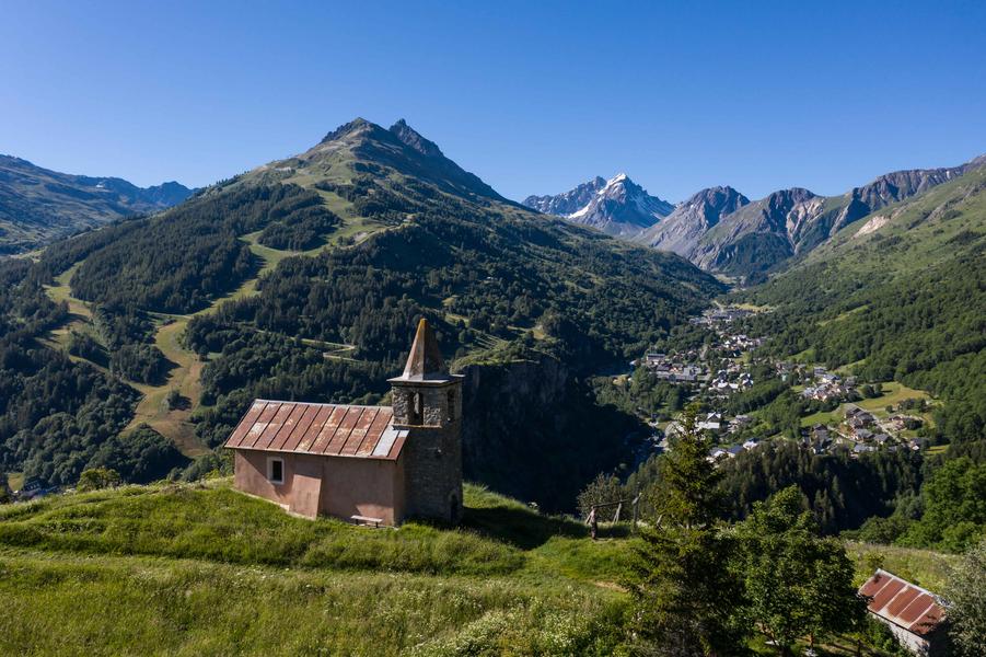
A short, easy loop that allows you to discover Valloire while gaining a little altitude, and enjoy lovely views of the Poingt-Ravier and Saint-Pierre chapel.
The characteristics of the route.

Office de tourisme de Valloire (73)
- Distance 9.48 km
- Elevation gain 450 m
- Elevation lost 450 m
- Min. elevation 1391 m
- Max. elevation. 1660 m
- Duration (depending on pace) 1h15
- Marking Yes
Marking : The trail is marked with yellow directional signs.Good plans : Your safety: - Bear in mind that you'll be riding in mountainous areas with sometimes technical trails, significant altitude differences and rapidly changing weather conditions. - Don't overestimate your abilities - Check the local weather forecast before setting off / www.meteofrance.com / tel: 3250 - Anticipate and adapt your clothing to the areas you'll be covering, and bring a survival blanket, windbreaker and whistle. - If you're going off on your own, be sure to provide those around you with information about your itinerary, and make sure you have a charged cell phone. - Always carry a supply of water. - Stay on marked paths. - Watch out for electric fences. - Make your presence known during hunting season (September to January) and in the vicinity of big game drives. - Help: in an emergency, call 112 Your environment : - Respect private property. - Don't light fires. - Keep your garbage and take it away. - Respect fruit crops and do not cross cultivated fields. - Don't frighten livestock. - Close park gates after passing through. Respect the direction of routes. Be careful and courteous when overtaking and crossing hikers.Admission fee : Free access.Opening : From 01/05 to 01/11 daily.
Subject to favorable snow and weather conditions.Step by step description : Departure: Valloire Tourist Office.
1/ Take the rue des écoles on your left as you leave the Office and head towards the campsite.
2/ Before crossing the bridge, turn left and follow the path along the river.
3/ Continue up towards La Borgé and take the "Chemin des Voûtes".
4/ Follow this path for about 1.5 kilometers to reach the hamlet of Poingt-Ravier. Before reaching the village center, turn left onto a path running alongside a meadow.
6/ Return to the Route du Galibier via a hairpin single overlooking the Gorges de l'Enfer.
7/ Before you reach the Pont de l'Enfer, turn left and continue downhill until you reach La Borgé again.
8/ Turn right at the junction with the Route du Galibier and follow the fitness trail almost as far as Le Verneys, then turn 180° onto a path that leads to Geneuil.
9/ This path leads down to a large track, on which you turn left in the direction of Chapelle St-Pierre. Continue to climb above the chapel before descending towards Carrefour Montagne.
10/ Go back down the Avenue de la Vallée d'or, turn left and return to the Tourist Office.
Report a problem
Website
Add your time and share your feelings
Services nearby

Notre Dame de l'Assomption Baroque Church
Place de l'église

Valloire Tourist Office
Rue des Grandes Alpes

Le Contoir - Restaurant
Route des Villards

Center de Soins ARNICA: health & well-being
Valloire

Facim Foundation
Valloire


Information updated on 2026-06-24 by Office de Tourisme de Valloire


Follow us on
the digital trails
the digital trails





Valloire Tourist Office
210 rue des Grandes Alpes - 73450 Valloire
+33(0)4 79 59 03 96
Office de Tourisme
Contact mail
 Valloire Galibier Expériences - Parcours - Boucle les Gorges de l’Enfer par Poingt Ravier - Itinéraire de trail
Hello, world! This is a toast message.
Valloire Galibier Expériences - Parcours - Boucle les Gorges de l’Enfer par Poingt Ravier - Itinéraire de trail
Hello, world! This is a toast message.
Valloire Galibier Expériences - Parcours - Boucle les Gorges de l’Enfer par Poingt Ravier - Itinéraire de trail
Hello, world! This is a toast message.


OK
Annuler