To the Agy Alpine Pasture - Hike
Add to my favorites

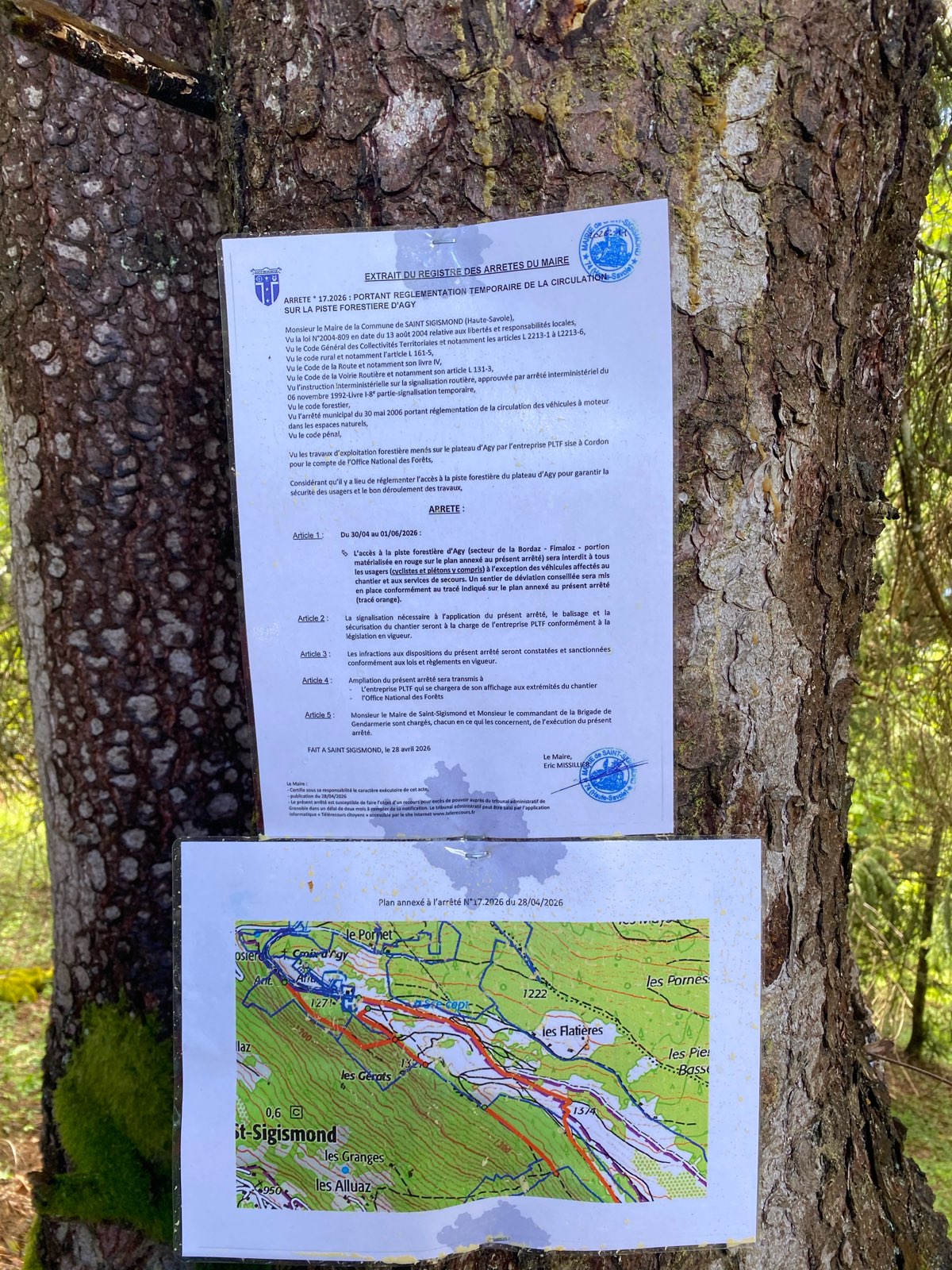
Caution! Zone of vigilance near the route
Boucle du Chevran - du 31/10/2025 au 30/10/2026 In progress
Route opened
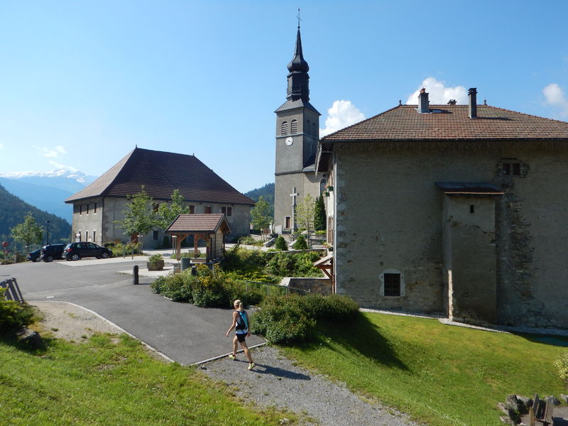
A pleasant walk through the woods, despite the steep climb at the start up to the mountain pastures of St-Sigismond. At the summit, enjoy the view of Mont Blanc and the Giffre Massif.
The characteristics of the route.
Saint-Sigismond (74)
- Distance 10.71 km
- Elevation gain 490 m
- Elevation lost 490 m
- Min. elevation 920 m
- Max. elevation. 1373 m
- Duration (depending on pace) 2h35
- Marking Yes
Step-by-Step Guide:
From the Saint-Sigismond Town Hall to Fimaloz: 2 hours Starting from the Town Hall, take the road toward Agy via Les Granges de la Frasse. Follow the arrows to the hamlet known as Chemin du Jourdil. From there, head up the road to the left. At the hairpin turn, take the trail on the left onto Chemin de la Berchère. Then continue along the dirt road until you reach a plateau with a beautiful view. Pass the barn, then turn immediately left, following signs for “Agy – La Croix.” Cross the stream, then head up the very damp path to the left. Next, cross the three footbridges in succession and take the trail that continues to the right into the forest. The trail then runs through the shade of the woods. When you reach Les Granges, follow the signs for “Agy (La Croix)” again. You’ll arrive at Les Chalets de Fimaloz, where you can enjoy a beautiful view. From Fimaloz to Agy (La Croix): 30 minutes. When you reach the signpost marked “Fimaloz,” follow the direction for “Agy (La Croix) via La Bordaz.” Then continue toward “Agy (La Croix).” You’ll pass by the restaurant La Tanière and the cross-country ski center. Once you’ve passed the parking lot, you’ll arrive at Agy (La Croix). From Agy (La Croix) to Les Hauts Choseaux: 40 minutes To descend from La Croix, retrace your steps. Return to the county road and follow the path to the left, which descends beneath the road. After about 500 meters, cross back over the road and continue downhill to the village of Agy. The trail crosses the road several times before reaching the hamlet of Les Hauts Choseaux. From Les Hauts Choseaux to the Saint-Sigismond town hall: 35 minutes At the intersection, go straight toward La Croix du Chêne. When you reach the cross, take the paved road on the left until it ends. The road continues and becomes a trail. At the intersection, turn left to reach the town hall parking lot.Want to go on a bike ride between Geneva and Chamonix? Say goodbye to cars and motorcycles—hop on your bike!Marking : Trail marked with directional posts (PDIPR)Equipments : Play area, Admission fee : Free access.Opening : From 01/04 to 15/11 daily. Depending on weather conditions. Canceled or closed.
From the Saint-Sigismond Town Hall to Fimaloz: 2 hours Starting from the Town Hall, take the road toward Agy via Les Granges de la Frasse. Follow the arrows to the hamlet known as Chemin du Jourdil. From there, head up the road to the left. At the hairpin turn, take the trail on the left onto Chemin de la Berchère. Then continue along the dirt road until you reach a plateau with a beautiful view. Pass the barn, then turn immediately left, following signs for “Agy – La Croix.” Cross the stream, then head up the very damp path to the left. Next, cross the three footbridges in succession and take the trail that continues to the right into the forest. The trail then runs through the shade of the woods. When you reach Les Granges, follow the signs for “Agy (La Croix)” again. You’ll arrive at Les Chalets de Fimaloz, where you can enjoy a beautiful view. From Fimaloz to Agy (La Croix): 30 minutes. When you reach the signpost marked “Fimaloz,” follow the direction for “Agy (La Croix) via La Bordaz.” Then continue toward “Agy (La Croix).” You’ll pass by the restaurant La Tanière and the cross-country ski center. Once you’ve passed the parking lot, you’ll arrive at Agy (La Croix). From Agy (La Croix) to Les Hauts Choseaux: 40 minutes To descend from La Croix, retrace your steps. Return to the county road and follow the path to the left, which descends beneath the road. After about 500 meters, cross back over the road and continue downhill to the village of Agy. The trail crosses the road several times before reaching the hamlet of Les Hauts Choseaux. From Les Hauts Choseaux to the Saint-Sigismond town hall: 35 minutes At the intersection, go straight toward La Croix du Chêne. When you reach the cross, take the paved road on the left until it ends. The road continues and becomes a trail. At the intersection, turn left to reach the town hall parking lot.Want to go on a bike ride between Geneva and Chamonix? Say goodbye to cars and motorcycles—hop on your bike!Marking : Trail marked with directional posts (PDIPR)Equipments : Play area, Admission fee : Free access.Opening : From 01/04 to 15/11 daily. Depending on weather conditions. Canceled or closed.
Area : Cluses Arve & Montagnes
Report a problem
Website PDF map THIS ROUTE IN YOUR MOBILE PHONE
Download Flaine Carroz 2ccam Outdoor app
Get all the routes on your smartphone with Flaine Carroz 2ccam Outdoor app. You'll find a host of functions :
- Take advantage of detailed IGN maps
- Download data for consultation even when you're not connected to the network
- Geolocate yourself at any time on the route and altimeter profile
- Activate the off-track alarm to be alerted if you stray from the itinerary
- Find nearby services
- Share your experience (add a report, share your lap time)...

DamC21
The 2026/05/12
En savoir plus
crissedechris
The 2025/04/22
En savoir plus
Ajouter votre chrono et partager vos sensations


Information updated on 2026-07-14 by Cluses Arve & montagnes Tourisme


Follow us on
the digital trails
the digital trails



Infos & contacts
Flaine Tourist Office
Tél. +33 (0)4 50 90 80 01
Les Carroz sports club
sports@aracheslafrasse.fr - Tél. +33 (0)4 50 90 24 80
Cluses Arve & montagnes Tourist Office
Tél. +33 (0)4 50 96 69 69
 Espace Trail Flaine - Les Carroz - Cluses Arve et Montagnes - Parcours - To the Agy Alpine Pasture - Hike
Hello, world! This is a toast message.
Espace Trail Flaine - Les Carroz - Cluses Arve et Montagnes - Parcours - To the Agy Alpine Pasture - Hike
Hello, world! This is a toast message.
Espace Trail Flaine - Les Carroz - Cluses Arve et Montagnes - Parcours - To the Agy Alpine Pasture - Hike
Hello, world! This is a toast message.




OK
Annuler