La Bastille
Add to my favorites

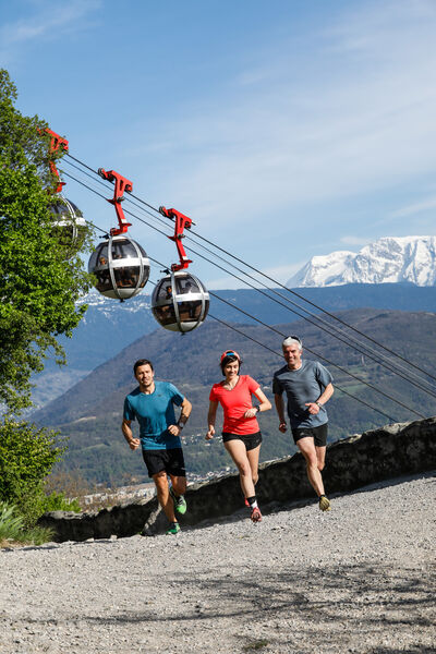
The trail starts gently along the Isère riverside to Guy Pape Park before climbing to La Bastille on a shaded path.
The characteristics of the route.
Grenoble (38)
- Distance 4.79 km
- Elevation gain 213 m
- Elevation lost 213 m
- Min. elevation 208 m
- Max. elevation. 421 m
- Marking Yes
After a few flights of steps that remind you these are fortifications, you'll reach the outer rampart wall. Before returning to the riverside via Guy Pape Park, you'll be rewarded for your efforts with a panoramic view over the city and the surrounding mountains as you pass below the "Bubbles" of Grenoble's cable car.
You'll find water at Porte Saint-Laurent, La Rochette and Quai Saint Laurent.Marking : Green trail markers The routes follow the hiking network and Trail markers are affixed to directional posts. In addition to the speci? c Trail signposting, you can also find your way by following the directions and markers on the ground.Admission fee : Free access.Opening : All year round.
You'll find water at Porte Saint-Laurent, La Rochette and Quai Saint Laurent.Marking : Green trail markers The routes follow the hiking network and Trail markers are affixed to directional posts. In addition to the speci? c Trail signposting, you can also find your way by following the directions and markers on the ground.Admission fee : Free access.Opening : All year round.
Read before you go!
The calculation of the dif?culty of each course takes into account the length, the positive vertical drop, the greatest continuous positive or negative vertical drop as well as the technicality of the terrain.
The calculation of the dif?culty of each course takes into account the length, the positive vertical drop, the greatest continuous positive or negative vertical drop as well as the technicality of the terrain.
Area : Grenoble-Alpes Métropole
Report a problem
Website Pdf file Pdf file Features of the application :
- Location and orientation on detailed maps thanks to the GPS of your smartphone
- Description of routes and points of interest on the route
- Photo gallery by route
- Detailed elevation profile
- Route tracking alert to warn you if you stray from the route
- Send predefined messages by SMS to your contacts
- Emergency module: trigger a call or send an emergency SMS in case of problem
- Agenda: access to events organized in the department
- News: find in the application the latest news on the web portal
- Adding achievements
- Add reports in case of problems encountered on the routes
- Share on social networks
zclemz
The 2022/09/13
En savoir plus
zclemz
finished in 00:32:01
The 2022/09/13
En savoir plus
Ajouter votre chrono et partager vos sensations
2022/09/13 zclemz
Le parcours commence par les quais, ce qui n'est pas très agréable avec la circulation de voiture, mais ça ne dure pas très longtemps. Ensuite la montée est assez dure. La trace gps n'est d'ailleurs pas precise au debut et un gros virage est indiqué par erreur. Il faut tout simplement suivre le balisage très présent dans la montée. Un peu de frustration de ne pas arriver au fort, mais la descente est agreable. La signalisation n'est plus vraiment présente mais il suffit de garder le plus grand chemin.
2022/09/13 00:32:01
zclemz
zclemz
Services nearby

Saint-Laurent Archaeological Museum, Grenoble
Grenoble
The Grenoble Museum of arts
Grenoble
The Old Bishop's Palace Museum
Grenoble

Bastille Tourist Information Center
Grenoble
Mountain Troops Museum
Grenoble


Information updated on 2023-07-07 by Office de Tourisme Grenoble Alpes


Follow us on
the digital trails
the digital trails


![]()
The Isère Outdoor application was created
by the Département de l'Isère
Infos & contact
Conseil départemental de l'Isère
7 rue Fantin Latour
CS 41096
38 022 Grenoble cedex 1
Tel. 04 76 00 38 38
 Isère Outdoor - Parcours - La Bastille
Hello, world! This is a toast message.
Isère Outdoor - Parcours - La Bastille
Hello, world! This is a toast message.
Isère Outdoor - Parcours - La Bastille
Hello, world! This is a toast message.


OK
Annuler