
Need some fresh air, a break from the everyday, and a chance to (re)connect with what really matters ? The Quercy Outdoor Hiking Area invites you to explore a land of trails where every step brings you closer to nature and local history.
From easy family walks to more challenging loops, set your own pace on waymarked paths that wind through oak forests, hidden valleys, dry stone walls, and charming villages.
Quercy and Bouriane offer a varied, authentic, and refreshing playground, where natural and cultural heritage reveal themselves along the way.
Let yourself be guided… and let yourself be surprised.


13.71km 440m 440m
SALVIAC
Route opened

8.68km 270m 270m
LEOBARD
Route opened

12.52km 350m 350m
SALVIAC
Route opened

9.11km 220m 220m
DEGAGNAC
Route opened

9.88km 290m 290m
CAZALS
Route opened

10.12km 310m 310m
LAVERCANTIERE
Route opened

6.41km 220m 220m
MARMINIAC
Route opened

7.12km 240m 240m
LES ARQUES
Route opened

18.71km 480m 480m
FRAYSSINET-LE-GELAT
Route opened

5.89km 110m 110m
MONTCLERA
Route opened

9.61km 260m 260m
GINDOU
Route opened

8.64km 220m 220m
MARMINIAC
Route opened

9.09km 210m 210m
THEDIRAC
Route opened

4.04km 110m 110m
LES ARQUES
Route opened

2.68km 70m 70m
LAVERCANTIERE
Route opened

5.12km 190m 190m
SALVIAC
Route opened

3.44km 110m 110m
PEYRILLES
Route opened

4.25km 110m 110m
PEYRILLES
Route opened

7.16km 200m 200m
SAINT-CIRQ-SOUILLAGUET
Route opened

6.49km 210m 210m
USSEL
Route opened

6.51km 240m 240m
GOURDON
Route opened

8.65km 180m 180m
LE VIGAN-EN-QUERCY
Route opened

8.7km 320m 320m
CONCORES
Route opened

15.64km 360m 360m
SAINT-CHAMARAND
Route opened

8.4km 240m 240m
ANGLARS-NOZAC
Route opened

7.4km 130m 130m
FAJOLES
Route opened

15.98km 320m 320m
GOURDON
Route opened

7.95km 260m 260m
LAMOTHE-CASSEL
Route opened

13.4km 330m 330m
Milhac
Route opened

9.96km 260m 260m
MONTAMEL
Route opened

11.35km 220m 220m
Payrignac
Route closed

14.95km 290m 290m
ROUFFILHAC
Route opened

5.33km 110m 110m
SAINT-CIRQ-MADELON
Route opened

4.63km 130m 130m
SAINT-CIRQ-SOUILLAGUET
Route opened

7.15km 270m 270m
SAINT-CLAIR
Route opened

9.37km 220m 220m
Saint-Germain-du-Bel-Air
Route opened

6.04km 140m 140m
SAINT-GERMAIN-DU-BEL-AIR
Route opened

11.12km 330m 330m
SAINT-PROJET
Route opened

8.11km 210m 210m
SOUCIRAC
Route opened

4.67km 150m 150m
UZECH
Route opened


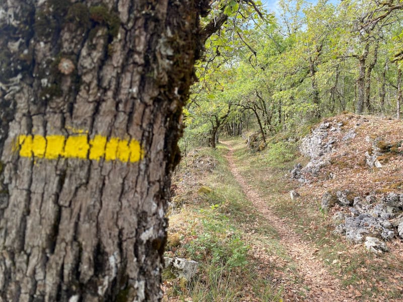
All the hiking routes are marked in the same way, with directional signs and PR yellow paint. The route numbers and difficulty levels do not appear on these markings.
Remember to take a map or topo sheet with you to check the directions. Topo sheets available from the Tourist Office.

Before your work out:
- Check the weather forecast right up to the time you leave
- Enquire about the condition of the route and its difficulty
- Inform someone of your planned route and schedules
- Take water and food with you
On the trail, please :
- Respect the natural and agricultural environments
- Stay on the trails and respect private properties
- Respect the highway code on public road
- Keep your garbage with you.
During the hunting season:
- Signal out loud
- Wear bright colors
- Meet the hunting team, who will inform you of the extent of their hunt and point you out to other hunters.

the digital trails


![]()
Infos & contacts
Tourist Office
Pays de Gourdon, Entre Lot & Dordogne
info@tourisme-gourdon.com
+33(0)5 65 27 52 50
Photo copyright
 Quercy Outdoor - Espace Hiking

