Lac de Chalvet
Add to my favorites

Route closed
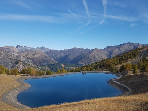
A circular route only on a 4x4 trackto join the Chalvet lake where you can picnic in the middle of nature.
The characteristics of the route.
Auron (06)
- Distance 14.6 km
- Elevation gain 570 m
- Elevation lost 570 m
- Min. elevation 1592 m
- Max. elevation. 2106 m
Read before you go!
- Suivez les sentiers balisés, ne prenez pas de raccourcis
- Avant de vous engager sur un parcours, vérifiez la météo, vérifiez qu’il est adapté à votre niveau et laissez votre itinéraire à quelqu’un.
- Soyez prudents.
- Redoublez d’attention en période de chasse et renseignez-vous sur les battues en cours.
- Si vous rencontrez des chiens de protection de troupeaux, restez calme, évitez les gestes brusques et contournez le troupeau.
- Respectez les propriétés privées, les zones de cultures et fermez les barrières après votre passage.
- Ayez un comportement éco-citoyen : remportez vos déchets et respectez la faune et la flore pour une nature préservée.
- Veillez à toujours télécharger l'itinéraire ( GPX ) correspondant à l’itinéraire concerné.
Area : Auron
Report a problem Add a comment
Add your time and share your feelings


Follow us on
the digital trails
the digital trails


![]()
Info & contacts
Offices de Tourisme du territoire
Auron : +33(0)4 93 23 02 66
St Etienne de Tinée : +33(0)4 93 02 41 96
St Dalmas le Selvage : +33(0)4 93 02 46 40


OK
Annuler