Belvédère d'Ublan
Add to my favorites

Route opened
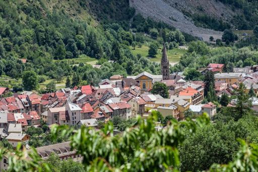
Starting from the village, reach the Trinitaires Chapel. You will take the famous GR5 in direction of the Anelle pass before reaching the Belvédère with a great view on the Tinée valley. The descent will be on a hiking trail, along the water, by following the Ublan canal. A journey in the heart of old agricultural terraces of the hamlet of Ublan.
The characteristics of the route.
Saint-Étienne-de-Tinée (06)
- Distance 5.1 km
- Elevation gain 290 m
- Elevation lost 290 m
- Min. elevation 1140 m
- Max. elevation. 1428 m
- Duration (depending on pace) 2h à 4h
Read before you go!
- Suivez les sentiers balisés, ne prenez pas de raccourcis
- Avant de vous engager sur un parcours, vérifiez la météo, vérifiez qu’il est adapté à votre niveau et laissez votre itinéraire à quelqu’un.
- Soyez prudents.
- Redoublez d’attention en période de chasse et renseignez-vous sur les battues en cours.
- Si vous rencontrez des chiens de protection de troupeaux, restez calme, évitez les gestes brusques et contournez le troupeau.
- Respectez les propriétés privées, les zones de cultures et fermez les barrières après votre passage.
- Ayez un comportement éco-citoyen : remportez vos déchets et respectez la faune et la flore pour une nature préservée.
- Veillez à toujours télécharger l'itinéraire ( GPX ) correspondant à l’itinéraire concerné.
Area : St Etienne de Tinée
Report a problem Add a comment
Add your time and share your feelings


Follow us on
the digital trails
the digital trails


![]()
Info & contacts
Offices de Tourisme du territoire
Auron : +33(0)4 93 23 02 66
St Etienne de Tinée : +33(0)4 93 02 41 96
St Dalmas le Selvage : +33(0)4 93 02 46 40


OK
Annuler