Rocher de Bramard
Add to my favorites

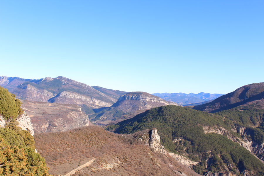
Rocher de Bramard
The characteristics of the route.
Sahune (26)
- Distance 11.95 km
- Elevation gain 640 m
- Elevation lost 640 m
- Min. elevation 350 m
- Max. elevation. 935 m
- Duration (depending on pace) 3h44
- Marking Yes
Parking behind the town hall, or on the public square on the banks of the Eygues, route de Montréal.
1. Cross the bridge over the Eygues and at the Fontaine du Pont (alt. 357m), turn left towards Quartier St-Jean. Drive alongside the municipal campsite, turning right after the small iron bridge.
2. 300m further on, at Quartier St-Jean (alt. 370m, letterbox in wall), turn left. Pass the first farm and take the small bridge on the right. Before the second farm, take the path on the right near the stream. Pass through the marl, close the gate and follow the path northwards towards the Eygues gorges. At mid-slope, the path joins a forest track, which you follow until you reach the Ferme du Laup post (chamois and roe deer are frequently seen in this area).
3. Turn right towards Rocher de Bramard. At the exit, follow a track on the right which turns into a path towards Ferme du Plus Haut Laup. Just before the farm, turn right and follow a faint path to a wide track. Turn right again. After 300m, turn left onto a track and climb for 30 minutes to the Tête de Bramard. Excellent views over the Sahune and Montréal valleys. Turn left along the edge of the rock to reach the highest point: Rocher de Bramard (alt. 936m).
4. After crossing the ridge, descend on a path through the boxwoods to reach a pass; take the right-hand path through a small oak wood. Join a track and turn right to descend into the valley. Join a field, cross the fence and go down the farm track. 200m before Bramard farm, turn left. Take the tarmac road back to Sahune, passing the campsite.Admission fee : Free access.Opening : All year round daily.
1. Cross the bridge over the Eygues and at the Fontaine du Pont (alt. 357m), turn left towards Quartier St-Jean. Drive alongside the municipal campsite, turning right after the small iron bridge.
2. 300m further on, at Quartier St-Jean (alt. 370m, letterbox in wall), turn left. Pass the first farm and take the small bridge on the right. Before the second farm, take the path on the right near the stream. Pass through the marl, close the gate and follow the path northwards towards the Eygues gorges. At mid-slope, the path joins a forest track, which you follow until you reach the Ferme du Laup post (chamois and roe deer are frequently seen in this area).
3. Turn right towards Rocher de Bramard. At the exit, follow a track on the right which turns into a path towards Ferme du Plus Haut Laup. Just before the farm, turn right and follow a faint path to a wide track. Turn right again. After 300m, turn left onto a track and climb for 30 minutes to the Tête de Bramard. Excellent views over the Sahune and Montréal valleys. Turn left along the edge of the rock to reach the highest point: Rocher de Bramard (alt. 936m).
4. After crossing the ridge, descend on a path through the boxwoods to reach a pass; take the right-hand path through a small oak wood. Join a track and turn right to descend into the valley. Join a field, cross the fence and go down the farm track. 200m before Bramard farm, turn left. Take the tarmac road back to Sahune, passing the campsite.Admission fee : Free access.Opening : All year round daily.
Report a problem
Add your time and share your feelings
Services nearby
Lou Cafetoun Bar-Restaurant
Curnier

Canyon découverte du Val d'Oule
Rémuzat
Neaclub les Lavandes Drôme Provençale
Rémuzat
L'Adrien
Rémuzat
La Scourtinerie
Nyons


Information updated on 2026-07-05 by Conseil départemental de la Drôme


Follow us on
the digital trails
the digital trails



 Espace Trail of Baronnies in Drôme Provençale - Parcours - Rocher de Bramard
Hello, world! This is a toast message.
Espace Trail of Baronnies in Drôme Provençale - Parcours - Rocher de Bramard
Hello, world! This is a toast message.
Espace Trail of Baronnies in Drôme Provençale - Parcours - Rocher de Bramard
Hello, world! This is a toast message.


OK
Annuler