Col de la Vôte
Add to my favorites

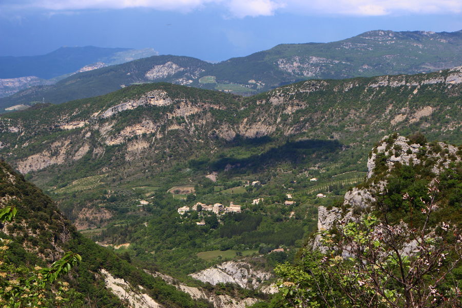
A hike to discover the valley of Montaulieu, a pretty hilltop village. No difficulty despite its length, thanks to the low gradient. The route can be followed by mountain bike.
The characteristics of the route.
Montaulieu (26)
- Distance 16.16 km
- Elevation gain 480 m
- Elevation lost 480 m
- Min. elevation 363 m
- Max. elevation. 760 m
- Duration (depending on pace) 4h20
- Marking Yes
Start: Car park just before reaching the village of Montaulieu.
1. Pass through the village, then head for Le Villard (road on the left after the church). The tarmac soon gives way to
continue on this passable track, which we'll be keeping for a very long time. After just over an hour (3.5 km), you'll pass the Villard equestrian center. Still on the same track, continue slightly uphill to reach the Col des Lantons (alt. 726 m).
2. From here, leave the signs for Buis-les-Baronnies (GR 9, straight ahead) and Col de Serriès (left), and turn right towards Col la Vôte.
3. Walk to the Col (multiple junction, alt. 701 m). Take the rightmost track (ONF gate always open). Stay on the main track, and after another barrier on the edge of the path, wind down the track to the right and then to the left. You pass a small meadow, continue downhill. Further down, several houses.
4. Reach the road; turn left, walk to the hamlet of St-Aubanet.
5. Follow the path under a porch. Stay on the main track, leaving several departures to the left and right. Follow the same path uphill to the village. You reach a small road. At the crossroads, turn left to reach the parking lot.Admission fee : Free access.Opening : All year round daily.
1. Pass through the village, then head for Le Villard (road on the left after the church). The tarmac soon gives way to
continue on this passable track, which we'll be keeping for a very long time. After just over an hour (3.5 km), you'll pass the Villard equestrian center. Still on the same track, continue slightly uphill to reach the Col des Lantons (alt. 726 m).
2. From here, leave the signs for Buis-les-Baronnies (GR 9, straight ahead) and Col de Serriès (left), and turn right towards Col la Vôte.
3. Walk to the Col (multiple junction, alt. 701 m). Take the rightmost track (ONF gate always open). Stay on the main track, and after another barrier on the edge of the path, wind down the track to the right and then to the left. You pass a small meadow, continue downhill. Further down, several houses.
4. Reach the road; turn left, walk to the hamlet of St-Aubanet.
5. Follow the path under a porch. Stay on the main track, leaving several departures to the left and right. Follow the same path uphill to the village. You reach a small road. At the crossroads, turn left to reach the parking lot.Admission fee : Free access.Opening : All year round daily.
Report a problem
Add your time and share your feelings
Services nearby
Lou Cafetoun Bar-Restaurant
Curnier
La Scourtinerie
Nyons
Musée du Scourtin
Nyons

Philippe Meffre
Nyons

Séjour sur-mesure
Nyons


Information updated on 2026-07-05 by Conseil départemental de la Drôme


Follow us on
the digital trails
the digital trails



 Espace Trail of Baronnies in Drôme Provençale - Parcours - Col de la Vôte
Hello, world! This is a toast message.
Espace Trail of Baronnies in Drôme Provençale - Parcours - Col de la Vôte
Hello, world! This is a toast message.
Espace Trail of Baronnies in Drôme Provençale - Parcours - Col de la Vôte
Hello, world! This is a toast message.


OK
Annuler