Notre Dame de Consolation
Add to my favorites

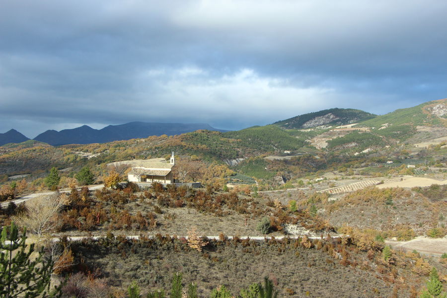
Legend has it that around 1630, a flock of sheep, led by a pious shepherdess, insisted on grazing on the arid
arid hilltop. It was then decided to build a sanctuary dedicated to the Blessed Virgin.
The characteristics of the route.
Arpavon (26)
- Distance 8.06 km
- Elevation gain 480 m
- Elevation lost 480 m
- Min. elevation 374 m
- Max. elevation. 785 m
- Duration (depending on pace) 2h23
- Marking Yes
Parking lot at the start of the path leading up to the Notre-Dame-de-Consolation chapel.
1. Climb the Way of the Cross towards the chapel. Leave the chapel on your right and continue for 1h through orchards
and oak woods. At the end of the path, take the footpath down to the Col d'Onglon, visible on the right below.
2. At the Col d'Onglon (alt. 640 m), follow the path to the right towards the Col de Sierry.
3. From this pass (alt. 719 m), the path continues along the ridge (l'Aiguillette). At the highest point, there's a magnificent panorama of the Autuche, Cougoir, Miélandre and Angèle mountains. Take care, however, as the path sometimes follows a rather impressive sheer drop to the left.
4. Further on, at Col des Sept Pommiers (alt. 699 m), turn right immediately, skirting the wood. As you come to the top of an old field, go around it to the right. Continue downhill on a path, then an old winding track. Cross a small ravine. Stay on the right-hand side of the ravine, passing the edge of an orchard, and a little further on, at the junction of the four paths, follow the one straight downhill. On the tarmac, turn right. This road takes you to the parking lot at the start.Admission fee : Free access.Opening : All year round daily.
1. Climb the Way of the Cross towards the chapel. Leave the chapel on your right and continue for 1h through orchards
and oak woods. At the end of the path, take the footpath down to the Col d'Onglon, visible on the right below.
2. At the Col d'Onglon (alt. 640 m), follow the path to the right towards the Col de Sierry.
3. From this pass (alt. 719 m), the path continues along the ridge (l'Aiguillette). At the highest point, there's a magnificent panorama of the Autuche, Cougoir, Miélandre and Angèle mountains. Take care, however, as the path sometimes follows a rather impressive sheer drop to the left.
4. Further on, at Col des Sept Pommiers (alt. 699 m), turn right immediately, skirting the wood. As you come to the top of an old field, go around it to the right. Continue downhill on a path, then an old winding track. Cross a small ravine. Stay on the right-hand side of the ravine, passing the edge of an orchard, and a little further on, at the junction of the four paths, follow the one straight downhill. On the tarmac, turn right. This road takes you to the parking lot at the start.Admission fee : Free access.Opening : All year round daily.
Report a problem
Add your time and share your feelings
Services nearby
Lou Cafetoun Bar-Restaurant
Curnier
La Scourtinerie
Nyons
Musée du Scourtin
Nyons

Philippe Meffre
Nyons

Séjour sur-mesure
Nyons


Information updated on 2026-07-05 by Conseil départemental de la Drôme


Follow us on
the digital trails
the digital trails



 Espace Trail of Baronnies in Drôme Provençale - Parcours - Notre Dame de Consolation
Hello, world! This is a toast message.
Espace Trail of Baronnies in Drôme Provençale - Parcours - Notre Dame de Consolation
Hello, world! This is a toast message.
Espace Trail of Baronnies in Drôme Provençale - Parcours - Notre Dame de Consolation
Hello, world! This is a toast message.


OK
Annuler