Tour du Grès
Add to my favorites

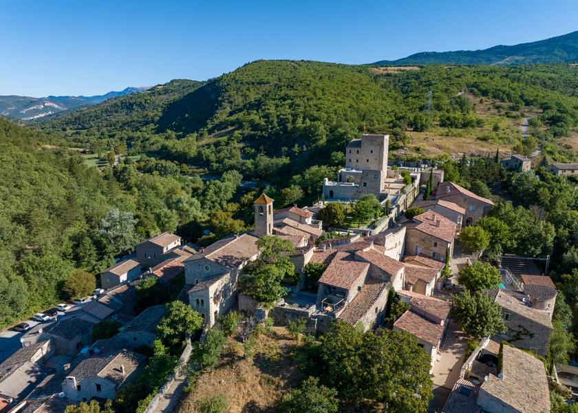
Tour du Grès
The characteristics of the route.
Sainte-Jalle (26)
- Distance 7.89 km
- Elevation gain 350 m
- Elevation lost 350 m
- Min. elevation 397 m
- Max. elevation. 735 m
- Duration (depending on pace) 2h12
- Marking Yes
Parking in front of the town hall.
Warning: this hike passes through a sheep park. Do not disturb the flock. Dogs forbidden on this route.
1. Take the road to Nyons, then the green metal bridge over the Ennuye. At the end, turn right. Pass a distillery, then, after the stone bridge, turn left. Follow this narrow road to the Vallon du Rieu Frais crossroads (alt. 430m, path with gate on right).
2. Take the path on the right. At a significant widening of the track, continue towards a "one-way" sign. Further on, the track becomes a path. Shortly afterwards, take the right-hand path and follow it to a track. Take the left-hand track, which winds upwards. At the summit, turn right onto a path, then head downhill towards the Col d'Onglon.
3. At the Col d'Onglon post (alt. 640m), turn left along the draye to the wide path visible in the valley (Le Moulin, alt. 480m).
4. Here, turn left, following the path into the valley. At the bridge, turn left and the narrow road joins the Vallon du Rieu Frais crossroads, then the village of Ste-Jalle.Admission fee : Free access.Opening : All year round daily.
Warning: this hike passes through a sheep park. Do not disturb the flock. Dogs forbidden on this route.
1. Take the road to Nyons, then the green metal bridge over the Ennuye. At the end, turn right. Pass a distillery, then, after the stone bridge, turn left. Follow this narrow road to the Vallon du Rieu Frais crossroads (alt. 430m, path with gate on right).
2. Take the path on the right. At a significant widening of the track, continue towards a "one-way" sign. Further on, the track becomes a path. Shortly afterwards, take the right-hand path and follow it to a track. Take the left-hand track, which winds upwards. At the summit, turn right onto a path, then head downhill towards the Col d'Onglon.
3. At the Col d'Onglon post (alt. 640m), turn left along the draye to the wide path visible in the valley (Le Moulin, alt. 480m).
4. Here, turn left, following the path into the valley. At the bridge, turn left and the narrow road joins the Vallon du Rieu Frais crossroads, then the village of Ste-Jalle.Admission fee : Free access.Opening : All year round daily.
Report a problem
Add your time and share your feelings
Services nearby
Lou Cafetoun Bar-Restaurant
Curnier
Village de Vacances La Fontaine d'Annibal
Buis-les-Baronnies
Camping la Fontaine d'Annibal
Buis-les-Baronnies
Sous l'Olivier
Buis-les-Baronnies

Baronnies Ventoux Aventures
Buis-les-Baronnies


Information updated on 2026-07-05 by Conseil départemental de la Drôme


Follow us on
the digital trails
the digital trails



 Espace Trail of Baronnies in Drôme Provençale - Parcours - Tour du Grès
Hello, world! This is a toast message.
Espace Trail of Baronnies in Drôme Provençale - Parcours - Tour du Grès
Hello, world! This is a toast message.
Espace Trail of Baronnies in Drôme Provençale - Parcours - Tour du Grès
Hello, world! This is a toast message.


OK
Annuler