La montagne de Peitieux
Add to my favorites

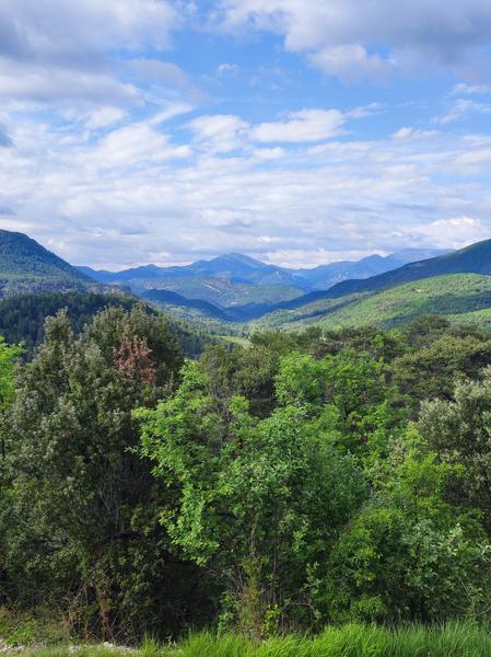
This tour takes you up the Peitieux mountain, which opens onto the eastern Baronnies of Provence. The valley boasts a remarkable geological heritage.
The characteristics of the route.
Châteauneuf-de-Bordette (26)
- Distance 7.73 km
- Elevation gain 420 m
- Elevation lost 420 m
- Min. elevation 433 m
- Max. elevation. 794 m
- Duration (depending on pace) 3h
- Marking Yes
Parking lot next to the St Michel chapel; about 500m from the Col de la Croix Rouge, hiking sign on the parking lot.
1. Take the narrow path at the end of the parking lot.
2. Join the road, then the Col de la Croix Rouge (alt. 513m). Take the DFCI track (GR9), marked in white and red. Stay on this track until you reach a crossroads: take the upper track. In a large
bend, leave the track and turn left onto a white-red path.
3. Further up, at the Peitieux crossroads (alt. 730m), follow the path straight ahead, leaving the white and red GR markings on the right. The whole climb is on the slopes of the Peitieux mountain, where the commune's old castle once stood. Conversely, the new castle (now also destroyed) was built on the slopes of Garde Grosse mountain (the mountain opposite). You soon reach the ridge.
4. Once up there, walk for about 300m, then leave the path for a downhill path to the left. At the bottom, cross a track and continue straight ahead.
5. Further down, reach the Col des Grands Champs, known locally as the Carrosserie. Continue on the same track. 300m further down, leave the track to take a path to the left: pass a large oak tree. Reach the bottom of a field, then take the path to the right, to reach the Gleizes-Haut fork (alt. 542m).
6. Turn right, then right again at the cairn. Descend to the road (Route des Pilles, alt. 450m). Cross the road to descend a steep path for a few metres. Catch up with the road, cross the bridge and climb back up for about 300m. At the farm, turn left.
7. At the pond (Les Mayets post, alt. 466m), leave the track and take the left-hand path. Cross the stream, then climb into the marl. Reach the bottom of an area of very old chestnut trees. These may have been planted due to the sandstone nature of the rock, which results in a more acidic soil. Further on, as you leave the wood, take a path between fields. At the end, turn left to reach the original chapel.Admission fee : Free access.Opening : All year round daily.
1. Take the narrow path at the end of the parking lot.
2. Join the road, then the Col de la Croix Rouge (alt. 513m). Take the DFCI track (GR9), marked in white and red. Stay on this track until you reach a crossroads: take the upper track. In a large
bend, leave the track and turn left onto a white-red path.
3. Further up, at the Peitieux crossroads (alt. 730m), follow the path straight ahead, leaving the white and red GR markings on the right. The whole climb is on the slopes of the Peitieux mountain, where the commune's old castle once stood. Conversely, the new castle (now also destroyed) was built on the slopes of Garde Grosse mountain (the mountain opposite). You soon reach the ridge.
4. Once up there, walk for about 300m, then leave the path for a downhill path to the left. At the bottom, cross a track and continue straight ahead.
5. Further down, reach the Col des Grands Champs, known locally as the Carrosserie. Continue on the same track. 300m further down, leave the track to take a path to the left: pass a large oak tree. Reach the bottom of a field, then take the path to the right, to reach the Gleizes-Haut fork (alt. 542m).
6. Turn right, then right again at the cairn. Descend to the road (Route des Pilles, alt. 450m). Cross the road to descend a steep path for a few metres. Catch up with the road, cross the bridge and climb back up for about 300m. At the farm, turn left.
7. At the pond (Les Mayets post, alt. 466m), leave the track and take the left-hand path. Cross the stream, then climb into the marl. Reach the bottom of an area of very old chestnut trees. These may have been planted due to the sandstone nature of the rock, which results in a more acidic soil. Further on, as you leave the wood, take a path between fields. At the end, turn left to reach the original chapel.Admission fee : Free access.Opening : All year round daily.
Report a problem
Add your time and share your feelings
Services nearby

Musée du Scourtin
Nyons
La Scourtinerie
Nyons

Philippe Meffre
Nyons

Ride your bike!
Nyons
Séjour sur-mesure
Nyons


Information updated on 2026-07-05 by Conseil départemental de la Drôme


Follow us on
the digital trails
the digital trails



 Espace Trail of Baronnies in Drôme Provençale - Parcours - La montagne de Peitieux
Hello, world! This is a toast message.
Espace Trail of Baronnies in Drôme Provençale - Parcours - La montagne de Peitieux
Hello, world! This is a toast message.
Espace Trail of Baronnies in Drôme Provençale - Parcours - La montagne de Peitieux
Hello, world! This is a toast message.


OK
Annuler