Roche d'Oie par les Costes
Add to my favorites

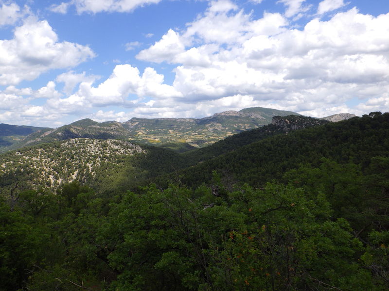
A quick stroll for a wide view from the rocky Roche d'Oie lookout. Beware, the descent is short but a little steep!
The characteristics of the route.
Pierrelongue (26)
- Distance 5.35 km
- Elevation gain 320 m
- Elevation lost 320 m
- Min. elevation 301 m
- Max. elevation. 623 m
- Duration (depending on pace) 2h
- Marking Yes
Starting out from the village of Pierrelongue, you can admire the Notre-Dame-de-la-Consolation church, perched on the 25m-high rocky outcrop that gives the village its name. It was built at the end of the 19th century by Abbé Pascaly, who wanted to replace the ruins of an ancient castle on the rock with "a sanctuary dedicated to the Virgin". Today, he rests beneath the crypt, in a tomb he had prepared for himself during his lifetime. Pierrelongue was also home to the "Petit train du Buis", the old railroad line between Orange and Buis-les-Baronnies. Last but not least, Pierrelongue specializes in pistou, a Provencal dish flavored with basil. A monument is dedicated to basil, a Confrérie des Chevaliers de la Soupe au Pistou has been created, and a Fête du Pistou is held around July 14th.
Start: Place de l'église, Pierrelongue
1. Exit Place de l'Eglise to the left. You will reach Place Saint-Brice. Follow the road to the left, cross the bridge and turn left onto chemin de Roche-d'Oie. Cross the D5 and take the Chemin des Grès opposite.
2. At the fork in the road, turn left onto chemin de Bellevue.
3. 150 m further on, leave the road and take the left-hand track. Stay on this main track along the stream.
4. After 600m you come to a fork in the road. Take the right-hand track.
5. Stay on the main track at the fork.
6 Leave the track and turn left onto a path that climbs through the woods. You then come out into the open, in a stony area, and follow the signs. You come to a flat area, which is the Roche d'Oie summit (alt. 626m on IGN).
7. Turn right, and the path descends. You soon enter undergrowth. The path then becomes a track.
8. At a cairn, turn left downhill. The trail soon turns right.
9. At the intersection (alt. 455m on IGN), continue straight ahead on the main downhill path.
10. Turn left at the fork. After 100m, cross a ford and return to the original junction. Follow the same route to the parking lot.Admission fee : Free access.Opening : All year round daily.
Start: Place de l'église, Pierrelongue
1. Exit Place de l'Eglise to the left. You will reach Place Saint-Brice. Follow the road to the left, cross the bridge and turn left onto chemin de Roche-d'Oie. Cross the D5 and take the Chemin des Grès opposite.
2. At the fork in the road, turn left onto chemin de Bellevue.
3. 150 m further on, leave the road and take the left-hand track. Stay on this main track along the stream.
4. After 600m you come to a fork in the road. Take the right-hand track.
5. Stay on the main track at the fork.
6 Leave the track and turn left onto a path that climbs through the woods. You then come out into the open, in a stony area, and follow the signs. You come to a flat area, which is the Roche d'Oie summit (alt. 626m on IGN).
7. Turn right, and the path descends. You soon enter undergrowth. The path then becomes a track.
8. At a cairn, turn left downhill. The trail soon turns right.
9. At the intersection (alt. 455m on IGN), continue straight ahead on the main downhill path.
10. Turn left at the fork. After 100m, cross a ford and return to the original junction. Follow the same route to the parking lot.Admission fee : Free access.Opening : All year round daily.
Report a problem
Add your time and share your feelings
Services nearby

Baronnies Cycle
Propiac

Baronnies Cycle
Propiac

Entre sentiers et gourmandises
Buis-les-Baronnies
Sentes & Cimes
Buis-les-Baronnies
La Buiscyclette
Buis-les-Baronnies


Information updated on 2026-07-05 by Conseil départemental de la Drôme


Follow us on
the digital trails
the digital trails



 Espace Trail of Baronnies in Drôme Provençale - Parcours - Roche d'Oie par les Costes
Hello, world! This is a toast message.
Espace Trail of Baronnies in Drôme Provençale - Parcours - Roche d'Oie par les Costes
Hello, world! This is a toast message.
Espace Trail of Baronnies in Drôme Provençale - Parcours - Roche d'Oie par les Costes
Hello, world! This is a toast message.


OK
Annuler