Les balcons d'Autuche
Add to my favorites

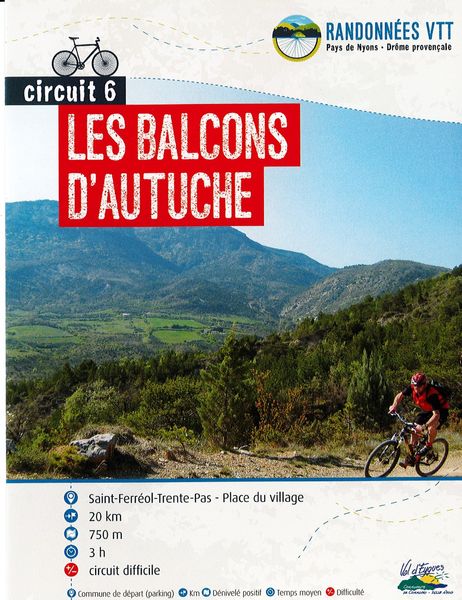
A physical circuit on both the ascent and descent, climbing the Col Aimond at the foot of the Mont Autuche, to take in the view of Mont Ventoux.
The characteristics of the route.

Saint-Ferréol-Trente-Pas (26)
- Distance 20.47 km
- Elevation gain 720 m
- Elevation lost 720 m
- Min. elevation 411 m
- Max. elevation. 846 m
- Duration (depending on pace) 2h14
- Marking Yes
The route begins on a quiet road towards the Col de Valouse to cross the gorges. The route continues on an uphill track to Col Aimont, with a view of Mont Ventoux. Be careful, the descent is very stony, so keep your strength up, as you won't forget either the last climb or the final descent.
Point 1: Village square (km 0).
Point 2: Le s Tilleuls (km 0.06 - 420m)
Left VTTn°6.
Point 3: Avant Grange neuve (km 5.7 - 700m)
Turn left off the D130.
Point 4: Marinon (km 7.5 - 746m)
Turn right.
Point 5: Col Aimont (km 9.63 - 856m)
Highest point on the circuit.
Point 6: Col de Fonturière (km 10.91 - 775m)
Turn left.
Point 7: La piste (km 11.44 - 755m)
Continue straight ahead on the track.
Point 8: L'Echalette (km 14.47 - 755m)
Turn left into private property. Big climb.
Point 9: Pied de Reyssas (km 16.87 - 690m)
In the hairpin bend, take the path straight ahead for 30m, then switch right onto the path, a fine descent to the campsite, then back to the village.Admission fee : Free access.Opening : All year round daily.
Point 1: Village square (km 0).
Point 2: Le s Tilleuls (km 0.06 - 420m)
Left VTTn°6.
Point 3: Avant Grange neuve (km 5.7 - 700m)
Turn left off the D130.
Point 4: Marinon (km 7.5 - 746m)
Turn right.
Point 5: Col Aimont (km 9.63 - 856m)
Highest point on the circuit.
Point 6: Col de Fonturière (km 10.91 - 775m)
Turn left.
Point 7: La piste (km 11.44 - 755m)
Continue straight ahead on the track.
Point 8: L'Echalette (km 14.47 - 755m)
Turn left into private property. Big climb.
Point 9: Pied de Reyssas (km 16.87 - 690m)
In the hairpin bend, take the path straight ahead for 30m, then switch right onto the path, a fine descent to the campsite, then back to the village.Admission fee : Free access.Opening : All year round daily.
Report a problem
Add your time and share your feelings
Services nearby
Lou Cafetoun Bar-Restaurant
Curnier
La Scourtinerie
Nyons
Musée du Scourtin
Nyons

Philippe Meffre
Nyons

Séjour sur-mesure
Nyons


Information updated on 2026-07-09 by Conseil départemental de la Drôme


Follow us on
the digital trails
the digital trails



 Espace Trail of Baronnies in Drôme Provençale - Parcours - Les balcons d'Autuche
Hello, world! This is a toast message.
Espace Trail of Baronnies in Drôme Provençale - Parcours - Les balcons d'Autuche
Hello, world! This is a toast message.
Espace Trail of Baronnies in Drôme Provençale - Parcours - Les balcons d'Autuche
Hello, world! This is a toast message.


OK
Annuler