Tour de la montagne Vaux
Add to my favorites

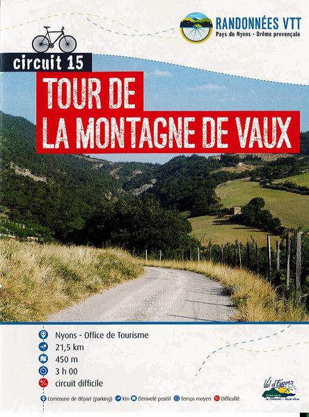
This tour takes in 2 areas: the Eygues valley with its Mediterranean vegetation, and the Combe de Sauve with its more alpine vegetation. The reward awaits you at the Col du Flachet: a magnificent view of the old village of Aubres.
The characteristics of the route.
Nyons (26)
- Distance 21.54 km
- Elevation gain 480 m
- Elevation lost 480 m
- Min. elevation 258 m
- Max. elevation. 662 m
- Duration (depending on pace) 2h15
- Marking Yes
The descent of the Combe de Sauve is technical and requires your full attention. Swimming possible in the combe in summer. Mixed circuit: dirt and tarmac.
Point 1: Place de la libération/Office de tourisme (km 0)
Point 2: Carrefour de la citadelle (km 0.8 - 279m)
After the tunnel, turn right and follow the red n°15 sign.
Point 3: Pont d'Aubres (km 4.3 - 284m)
Cross the bridge and continue straight on towards the village.
Point 4: Rond point de l'école (km 5.1 - 300m)
Turn left, then right after 200m towards Le Flachet at Place de Maupas. High gradient before reaching the pass.
Point 5: Col du Flachet (km 11 - 665m)
Straight on towards the Combe de Sauve. Technical descent.
Point 6: Combe de Sauve (km 12.1 - 510m)
Take the tarmac road on your left.
Point 7: RD 538 (km 15.4 - 402m)
Take care when crossing the main road. Follow the path and then the road to Nyons, on the right bank of the Sauve.Admission fee : Free access.Opening : All year round daily.
Point 1: Place de la libération/Office de tourisme (km 0)
Point 2: Carrefour de la citadelle (km 0.8 - 279m)
After the tunnel, turn right and follow the red n°15 sign.
Point 3: Pont d'Aubres (km 4.3 - 284m)
Cross the bridge and continue straight on towards the village.
Point 4: Rond point de l'école (km 5.1 - 300m)
Turn left, then right after 200m towards Le Flachet at Place de Maupas. High gradient before reaching the pass.
Point 5: Col du Flachet (km 11 - 665m)
Straight on towards the Combe de Sauve. Technical descent.
Point 6: Combe de Sauve (km 12.1 - 510m)
Take the tarmac road on your left.
Point 7: RD 538 (km 15.4 - 402m)
Take care when crossing the main road. Follow the path and then the road to Nyons, on the right bank of the Sauve.Admission fee : Free access.Opening : All year round daily.
Report a problem
Add your time and share your feelings
Services nearby
Séjour sur-mesure
Nyons

Baronnies- Paragliding - « Lou Ventoun »
Nyons
Ride your bike!
Nyons
Coups de pédale dans les vignobles
Nyons
Sports Evasion 26
Nyons


Information updated on 2026-07-09 by Conseil départemental de la Drôme


Follow us on
the digital trails
the digital trails



 Espace Trail of Baronnies in Drôme Provençale - Parcours - Tour de la montagne Vaux
Hello, world! This is a toast message.
Espace Trail of Baronnies in Drôme Provençale - Parcours - Tour de la montagne Vaux
Hello, world! This is a toast message.
Espace Trail of Baronnies in Drôme Provençale - Parcours - Tour de la montagne Vaux
Hello, world! This is a toast message.


OK
Annuler