
Hiking
routes filtered
Only my favorites
Delete filters
Around me :
< 5km
< 10km
< 25km
< 50km
Inactive
Difficulties :
Easy
Medium
Difficult
Expert
Durée :
<1h
1-2h
2-3h
3-4h
>4h
Distance (km) :
<10
10-25
25-50
50-75
>75
Distance (km) :
<25
25-50
50-100
100-150
>150
Elevation gain (m) :
<500
500-1000
1000-1500
1500-2500
>2500
Elevation lost (m) :
<500
500-1000
1000-1500
1500-2500
>2500
Tags :
Areas :
Rando 1 : Corbara - Pigna - Varcale
10.25km 320m 320m
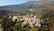
Corbara
Route opened
10.25km 320m 320m
Corbara
Route opened
Rando 2 : Boucle de San Ciprianu
6.18km 250m 250m
Pigna
Route opened
6.18km 250m 250m
Pigna
Route opened
Rando 3 : Corbara - Carbunaghja
3.93km 220m 220m
Corbara
Route opened
3.93km 220m 220m
Corbara
Route opened
Rando 4 : Tour de la Cima Sant'Anghjulu
8.88km 440m 440m
Corbara
Route opened
8.88km 440m 440m
Corbara
Route opened
Hiking n°5 - Walk around the hamlets of Santa Reparata di Balagna
3.9km 150m 150m
Santa-Reparata-di-Balagna
Route opened
3.9km 150m 150m
Santa-Reparata-di-Balagna
Route opened
Rando 6 : Giru L'Île-Rousse - Sta Reparata - Monticello
12.22km 410m 410m
L'Île-Rousse
Route opened
12.22km 410m 410m
L'Île-Rousse
Route opened
Hike 7: Loop around the Codole dam
11.47km 310m 310m
Santa-Reparata-di-Balagna
Route opened
11.47km 310m 310m
Santa-Reparata-di-Balagna
Route opened
Rando 8 : Funtana Suprana
1.53km 50m 50m
Monticello
Route opened
1.53km 50m 50m
Monticello
Route opened
Rando 9 : Fiuminale Cala d'Alivu
7.51km 280m 280m
Monticello
Route opened
7.51km 280m 280m
Monticello
Route opened
Hike 10: Arbo Valley loop
7.25km 260m 260m
Monticello
Warning
7.25km 260m 260m
Monticello
Warning
Hiking 11 : Santa Reparata tour
11.84km 580m 580m
Santa-Reparata-di-Balagna
Route opened
11.84km 580m 580m
Santa-Reparata-di-Balagna
Route opened
Rando 12 : Giru Occiglioni-Palmentu
6.1km 280m 280m
Santa-Reparata-di-Balagna
Route opened
6.1km 280m 280m
Santa-Reparata-di-Balagna
Route opened
Rando 13: Loop around L'Ile-Rousse
39.62km 1500m 1500m
L'Île-Rousse
Warning
39.62km 1500m 1500m
L'Île-Rousse
Warning
Rando 14 : Vallée du Reginu
28.09km 830m 830m
L'Île-Rousse
Route opened
28.09km 830m 830m
L'Île-Rousse
Route opened
Rando 15 : Sentier E Spelonche
9.25km 410m 410m
Belgodère
Route opened
9.25km 410m 410m
Belgodère
Route opened
Rando 16 : Boucle de Sant'Antone
10.96km 690m 690m
Belgodère
Route opened
10.96km 690m 690m
Belgodère
Route opened
Rando 17 : Monte Astu
13.1km 1050m 1050m
Lama
Route opened
13.1km 1050m 1050m
Lama
Route opened
Rando 18 : Boucle de Casenove
3.78km 220m 220m
Pietralba
Route opened
3.78km 220m 220m
Pietralba
Route opened
Hike 19: Alzone loop
12.24km 600m 600m
Vallica
Route opened
12.24km 600m 600m
Vallica
Route opened
Rando 20 : Tour des villages du Ghjunsani
14.46km 690m 690m
Olmi-Cappella
Route opened
14.46km 690m 690m
Olmi-Cappella
Route opened

Rando 21 : Boucle de San Bastianu
5.25km 250m 250m
Occhiatana
Route opened
5.25km 250m 250m
Occhiatana
Route opened
Rando 22 : Boucle de Giustiniani
7.67km 370m 370m
Speloncato
Route opened
7.67km 370m 370m
Speloncato
Route opened
Rando 22bis: Giustiniani heritage path
2.75km 150m 150m
Speloncato
Route opened
2.75km 150m 150m
Speloncato
Route opened
Rando 23 : Boucle de Sant'Andria (Feliceto)
3.45km 130m 130m
Feliceto
Route opened
3.45km 130m 130m
Feliceto
Route opened

Rando 23 : Boucle de Sant'Andria (Nessa)
4.79km 210m 210m
Nessa
Route opened
4.79km 210m 210m
Nessa
Route opened
Hiking 24 : Montegrosso - Muro - Zilia
12.02km 820m 820m
Montegrosso
Route opened
12.02km 820m 820m
Montegrosso
Route opened

Hiking 25 : Montegrosso
5.27km 210m 210m
Montegrosso
Route opened
5.27km 210m 210m
Montegrosso
Route opened

Hiking 26 : Occi
4.94km 280m 280m
Lumio
Route opened
4.94km 280m 280m
Lumio
Route opened

Hike 27: Pieve d'Aregno
9.94km 510m 510m
Lavatoggio
Warning
9.94km 510m 510m
Lavatoggio
Warning

Hiking 28 : Revellata
13.77km 280m 280m
Calvi
Route opened
13.77km 280m 280m
Calvi
Route opened

Hiking 29 : Focolara
16.55km 1060m 1060m
Galéria
Route opened
16.55km 1060m 1060m
Galéria
Route opened

Hike 30 : Prunicciale
8.84km 260m 260m
Manso
Route opened
8.84km 260m 260m
Manso
Route opened
Rando 31: Saleccia loop
11km 260m 260m
L'Île-Rousse
Warning
11km 260m 260m
L'Île-Rousse
Warning
Hiking 32 : San Pancraziu
4.5km 600m 20m
Urtaca
Route opened
4.5km 600m 20m
Urtaca
Route opened
Rando 33 : Lama heritage path
3.4km 240m 240m
Lama
Route opened
3.4km 240m 240m
Lama
Route opened
Rando 34 : Bocca di Tenda
9.5km 750m 750m
Pietralba
Route opened
9.5km 750m 750m
Pietralba
Route opened
Rando 35 : Natura 2000 - Vallica
7.33km 370m 370m
Vallica
Route opened
7.33km 370m 370m
Vallica
Route opened
Rando 37 : Forcili heritage path
1.91km 80m 80m
Pioggiola
Route opened
1.91km 80m 80m
Pioggiola
Route opened
Hike 38 : Giru di a cima Tornaghja
8.57km 330m 330m
Pioggiola
Route opened
8.57km 330m 330m
Pioggiola
Route opened
Hiking 41 : Feliceto - Muro
8.06km 390m 390m
Feliceto
Route opened
8.06km 390m 390m
Feliceto
Route opened

Rando 42: Algajola loop
7.24km 80m 80m
Algajola
Route closed
7.24km 80m 80m
Algajola
Route closed

Rando 43 : Bocca Capronale
16.68km 1200m 1200m
Manso
Route opened
16.68km 1200m 1200m
Manso
Route opened
International
France
 Lisula - Outdoor & Trail - Liste des activités

