
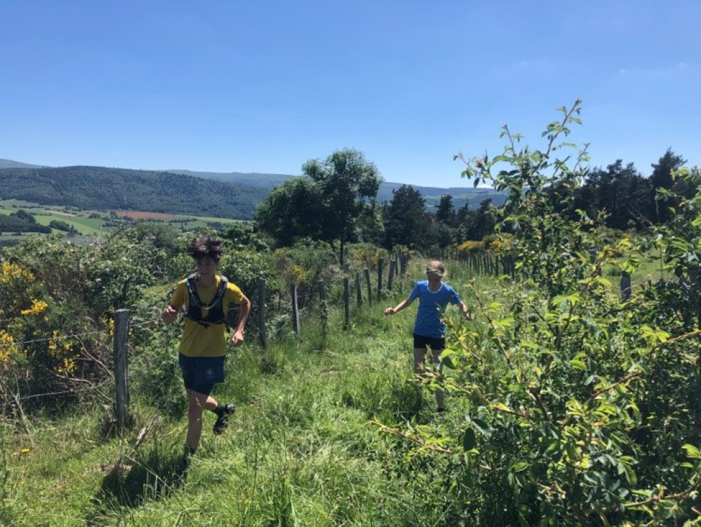
Combine culture, nature and sport !
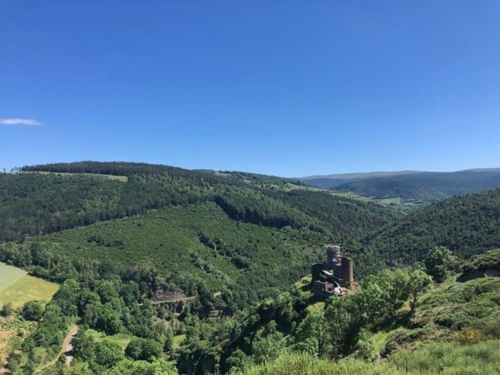
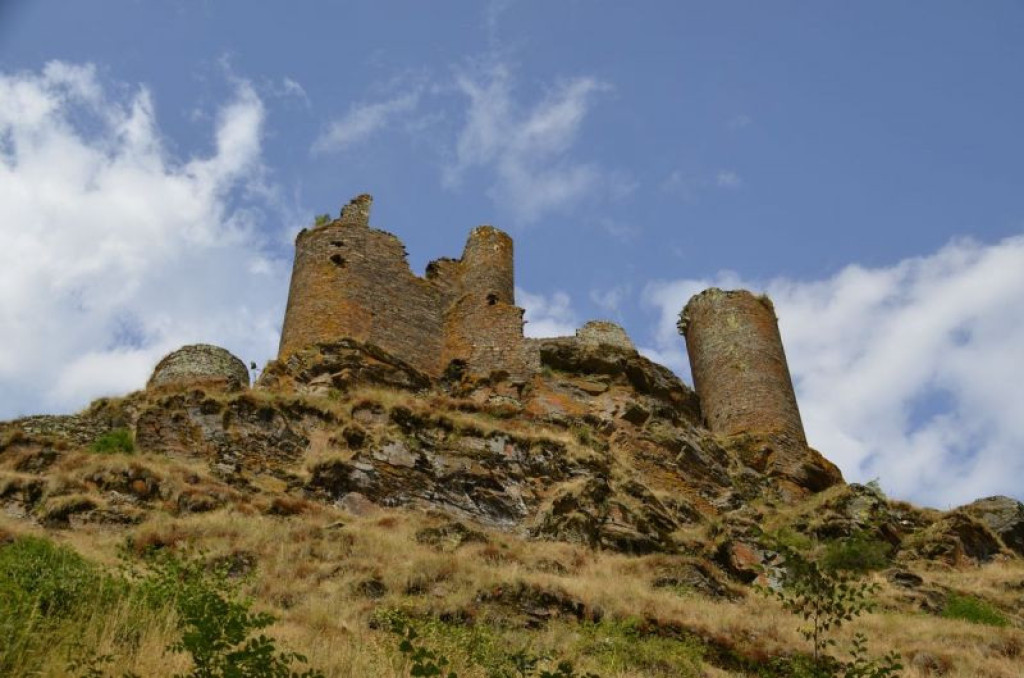
Explore Lozerette, Mas d'Orcières and the Château du Tournel as your legs see fit. The uphill sections will hone your calf muscles and the magnificent panoramic views will fill your eyes. A large-scale adventure!

- Distance 20.4 km
- Elevation gain 820 m
- Elevation lost 820 m
- Min. elevation 902 m
- Max. elevation. 1237 m
- Duration (depending on pace) 2h30
- Suivre le balisage Yes

Signposts will guide you all along this route: follow the waymarks for trail #10
The circuit starts with a fairly steep but pleasant uphill section, on a pretty path in the forest, leading to the typical Mont Lozère village of Oultet, with its blizzard bell-tower, stone houses and old bread oven. Once you have crossed the village, you start again on a magnificent path, initially between meadows and forest, with the river nearby (the ground is often slippery). Then you start a beautiful climb with superb views throughout. This takes you to Lozerette, a village that rarely leave visitors indifferent. Here you take a track that descends gently to the hamlets of Cheyroux and Le Mas. A few steps on tar to reach Orcières, then a great, almost flat section on a path between forest and pastureland. A slightly steep descent takes you to the Lot river, which you cross to begin the climb to the Château du Tournel. Take the time to visit the castle before getting started on the climb to Malmont, which is very pretty but steep. Once you have arrived at the road and the hamlet, you’ll have finished climbing! A great zigzagging path with handsome views of the castle takes you down to Saint-Julien-du-Tournel. Go through the village to reach a path that goes back downhill to the starting-point (there is one last hump – prepare yourself mentally!).
Signposts will guide you all along this route, as well as yellow painted waymarks. In the description below, the signposted place names and/or directions are given in bold italics between quotation marks:
At "Bagnols-les-Bains » ", go to « Oultet » via :
- « Avenue de la Gare »,
- « Route de la Loubière »,
- « La Destourbe »,
- « La Montagnac »,
- « Lou Peyrou » .
- À « Oultet » continuer sur
- « Lozerette », puis direction
- « Les Quincos »,
- « Village »,
- « Orcières » . Descendre sur « Château du Tournel » par /
- « Bois Dario »,
- « Le Tournel »,
- « Sous le Château ».
- Au « Château du Tournel » monter au village de Malmont par
- « Les Parets »,
- « La Combe », puis descendre à « Saint-Julien du Tournel » par
- « Lavignolles » (attention traversée de route).
- À « Saint-Julien du Tournel » retour à « Bagnols-les-Bains » par
- « La Dabalade »,
- « Lou Mapas »,
- « La Destourbe », « Route de la Loubière », « Avenue de la Gare ».
This hike is taken from the guidebook Mont Lozère – Pays des sources, de la montagne du Goulet aux gorges du Bramont, published by the Pôle de pleine nature du Mont Lozère.
Parking : parking des Thermes
Avant de vous engager sur un circuit, vérifiez qu'il est adapté à votre activité et à votre niveau. N'oubliez pas que le temps change vite en montagne. Refermez bien les clôtures et les portillons. Restez sur les chemins balisés.
Get all the routes on your smartphone with the Lozère outdoor app. You'll find all outdoor activities (summer and winter seasons) and a host of functions :
- Take advantage of detailed IGN maps
- Download data for consultation even when you're not connected to the network
- Geolocate yourself at any time on the route and altimeter profile
- Activate the off-track alarm to be alerted if you stray from the itinerary
- Share your experience (add a report, share your lap time)...


the digital trails


![]()
The Lozère Outdoor application was created
by the Lozère Department
Infos & contacts
Conseil départemental de la Lozère
sportsnature@lozere.fr
+33(0)4 66 49 66 32
Crédits photos
 Lozère Outdoor - Parcours - Château du Tournel, #10
Lozère Outdoor - Parcours - Château du Tournel, #10
Lozère Outdoor - Parcours - Château du Tournel, #10
Lozère Outdoor - Parcours - Château du Tournel, #10
Lozère Outdoor - Parcours - Château du Tournel, #10

