Circuit 53. GRP® TVO : Col d'Aubisque/Eaux-Bonnes par Gourette
Add to my favorites

Posible snow cover
Warning
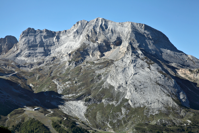
This stage, which goes from the Col d’Aubisque to Gourette and ends in Eaux-Bonnes, links three major sites in the valley's tourism developments. The setting is sumptuous, dominated by the Pic de Ger.
The characteristics of the route.
Béost (64)
- Distance 15.95 km
- Elevation gain 650 m
- Elevation lost 1620 m
- Min. elevation 736 m
- Max. elevation. 1798 m
- Duration (depending on pace) 6h30
- Marking GRP®
You may notice differences between the distance and elevation data displayed on the digital tools and the pdf file due to different data sources.
Report a problem
PDF_Files_Hiking53_Col d'Aubisque Eaux Bonnes Fiche PDF GRP® Tour de la Vallée d'Ossau - Etape Col d'Aubisque / Eaux-Bonnes 2025
Add your time and share your feelings
Services nearby
ISKÖ Chalets - Hötel
GOURETTE
Chalet Club Alpin Français
GOURETTE
Hôtel Amoulat
GOURETTE
Gourette charging station
Gourette

l'Etoile des Neiges
GOURETTE


Follow us on
the digital trails
the digital trails


![]()
The Ossau Valley Tourist Office
Welcome desk of Laruns
Maison de la Vallée d’Ossau – 64 440 LARUNS
+33(0)5 59 05 31 41
Tourist Office
 Ossau valley Land of adventures - Parcours - Circuit 53. GRP® TVO : Col d'Aubisque/Eaux-Bonnes par Gourette
Hello, world! This is a toast message.
Ossau valley Land of adventures - Parcours - Circuit 53. GRP® TVO : Col d'Aubisque/Eaux-Bonnes par Gourette
Hello, world! This is a toast message.
Ossau valley Land of adventures - Parcours - Circuit 53. GRP® TVO : Col d'Aubisque/Eaux-Bonnes par Gourette
Hello, world! This is a toast message.


OK
Annuler